Chairman's Message
The adoption of our county’s latest long-range transportation plan comes at a time of
tremendous change.
The passage of the Infrastructure Investment
and Jobs Act (IIJA), also known as the
Bipartisan Infrastructure Law, or BIL, in
November 2021 injected an additional
$13 billion over the law’s five-year life into
Pennsylvania transportation. Of that amount,
$14.59 million was dedicated to Franklin
County, which allowed us to add 15 previously
deferred projects to our transportation
construction program.
Nevertheless, challenges remain. Although
there are millions available in new federal
dollars through formula and discretionary
programs, local governments are struggling
to raise the local match required to secure
new federal funds. Soaring inflation is
diminishing our buying power. Franklin
County’s population continues to surge—
numbers from the 2020 U.S. Census reveal
that the county registered its 23rd consecutive
decennial population increase since its
founding in 1784. This translates to growing
demand for transportation infrastructure and
services, and is reflected in changes to our
landscape, as warehousing, distribution, and
intermodal centers consume our farms and
open spaces.
As we look ahead, we can expect to grapple
with the economic and transportation changes
that were wrought by the COVID-19 pandemic
and its aftermath. The following influences
are expected to change how we plan for the
county’s future:
- Federal performance-based planning and programming requirements;
- Shifting approaches and technologies related to transportation asset management;
- Increased focus on resiliency of the transportation system relative to weather-related events;
- Expansion of mobility options, including deployment of new technology and changes in land-use patterns;
- The imperative to address the needs of both our urban and rural communities; and
- Challenges in generating local matching funds to secure the new federal funding being made available through IIJA/BIL.
This document, our latest long-range transportation plan, provides us with a framework for addressing these challenges to ensure that our transportation system remains a strategic asset for our county’s continued mobility and economic vitality. I invite your review of the plan and ask you to join us as we work together to ensure we maintain a dependable and sustainable transportation system for Franklin County.

Franklin County Metropolitan Planning Organization
Geographic Position
Overview
- Located in South Central Pennsylvania, Franklin County is 772 square miles in size and features a largely rural landscape. It is situated on Pennsylvania’s southern border: the Mason-Dixon line marks its boundary with Washington County in Maryland (Figure 1).
- The county is located within Pennsylvania’s Ridge-and-Valley region, distinctive for its fertile farmland and thin-soil landscape. During the early part of the nation’s history, the “Great Valley” served as a major travel corridor from the East Coast to the nation’s interior. Today, it serves as a conduit for highways such as US 11 and Interstate 81.
- The county’s most populous municipality is Chambersburg Borough, which had 21,903 residents as of the 2020 U.S. Census. Other urban centers include Greencastle, Waynesboro, and Shippensburg, which straddles the county’s border with neighboring Cumberland County.
- Franklin County includes the Chambersburg-Waynesboro Micropolitan Statistical Area, one of 20 such regions in Pennsylvania. It borders two surrounding Metropolitan Statistical Areas (MSAs), those of the Hagerstown-Martinsburg MSA and the Harrisburg-Carlisle MSA.
- Franklin County is considered part of the Northeast Megalopolis, a geographical area defined by the Regional Plan Association indicating a large scale of regional economies, shared natural resources, interconnected transportation systems, and densely developed urban populations stretching from Boston, MA, to Richmond, VA.
- The county is adjacent to the federally designated Appalachian Region, which includes surrounding counties such as Fulton and Perry. The county’s western border with Fulton County features a 1,500-foot-high escarpment (long cliff) which has historically been a barrier to east-west transportation.
- The center of the county is located within a 90-minute drive of jobs and attractions in suburban Baltimore and Washington, D.C.
- The county’s strategic position within major market areas and along the Interstate 81 corridor make it an attractive location for warehousing and distribution centers.
Figure 1: Franklin County's Geographic Position
Franklin County Transportation Timeline
1831
Cumberland Valley Railroad (CVRR) incorporated
1837
CVRR reaches Chambersburg
1924
First segments constructed of US 30/Lincoln Highway—the first transcontinental highway in the U.S.
1940
PA Turnpike opens
1960
First segments of I-81 constructed
1969
Franklin County’s population exceeds 100,000
1995
Conrail donates former rail corridor to Cumberland Valley Rails-to-Trails Council
2000
BicyclePA Route S designated
2003
Daily vehicle-miles traveled (DVMT) exceeds 4 million for the first time
2005
I-81 Exit 17 constructed
2007
CSX opens intermodal yard in Chambersburg
2013
Franklin County Metropolitan Planning Organization designated
2013
Norfolk Southern opens intermodal yard in Greencastle
2025
I-81 Exit 12 interchange slated to open
LRTP Purpose
What is an LRTP?
The long-range transportation plan (LRTP)
establishes goals and potential projects to
improve the transportation system in Franklin
County, consistent with the county’s overall
vision. The LRTP considers a 25-year planning
horizon and provides a framework for making
transportation decisions that will support the
county’s desired future.
Specifically, the LRTP inventories and
assesses the county’s current land use,
transportation patterns, and the operations of
all transportation modes. The LRTP identifies
needed improvements to the multimodal
transportation system—highway/bridge, rail,
air, transit, bicycle, and pedestrian facilities—to
facilitate a desired long-term outcome.
The LRTP is guided by the Franklin County
Metropolitan Planning Organization (MPO)
and serves several key functions, including:
- Serving as the transportation element of the Franklin County Comprehensive Plan;
- Guiding the MPO’s decisions on project prioritization for the Transportation Improvement Program (TIP);
- Advising the county’s 22 municipalities on local and regional planning decisions that impact transportation;
- Fulfilling federal and state transportation laws and regulations; and
- Reflecting the needs and priorities of Franklin County’s residents, visitors, and businesses.
What is an MPO?
A metropolitan planning organization (MPO) is a transportation policy-making body comprised of representatives of local government and transportation agencies that own, operate, and fund transportation infrastructure. Federal law requires the formation of an MPO in any urbanized area with a population greater than 50,000; Franklin County became an MPO due to population growth reflected in the 2010 U.S. Census. MPOs ensure that decisions and spending on transportation projects and programs are based on a “continuing, comprehensive, and cooperative” (3C) planning process that reflects the needs and priorities of the county. MPOs administer federal and state funding for transportation projects and programs, consistent with the approved LRTP.
Why Develop an LRTP for Franklin County?
Developing and regularly updating an LRTP is a prerequisite to receiving federal transportation funding. Further, it helps ensure that transportation investment decisions are made strategically and considered in light of their long-term effect on the county.
Transportation decisions profoundly shape the county’s direction and growth. An LRTP helps determine what improvements are needed to guide the county in a cohesive, agreed-upon direction for the future. Without this solid direction, growth would occur in an unplanned and incremental manner, likely to the detriment of what makes Franklin County a great place in which to live, work, or visit.
What are the MPO's responsibilities?
The Metropolitan Planning Organization (MPO) is the official transportation planning organization for Franklin County recognized by the Pennsylvania Department of Transportation (PennDOT) and the Federal Highway Administration (FHWA). Federal law and regulations establish five core functions of an MPO. The Secretary of Transportation on behalf of the Governor of Pennsylvania designated Franklin County as an MPO on March 27, 2013. The MPO succeeded the Franklin County Rural Planning Organization (RPO), which was established in May 2009.
Responsibilities
- Prepare and maintain a Long-Range Transportation Plan considering a period of at least 20 years.
- Establish and manage a fair and impartial setting for effective regional decision-making in the transportation planning area.
- Identify and evaluate alternative transportation improvement options by using data and planning methods to generate and evaluate alternatives.
- Develop a Transportation Improvement Program (TIP)—a short-range (four-year) program of transportation improvements based on the LRTP.
- Involve the general public and all significantly affected sub-groups residing in Franklin County in the four core functions listed previously
Demographics
Overview and Key Trends
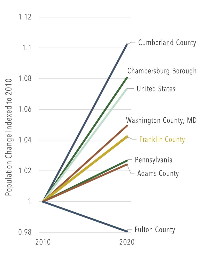
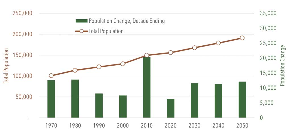
- Franklin County had a 2020 population of 155,932. Since 2010, the county has added approximately 6,000 people (Table 1; Figure 3).
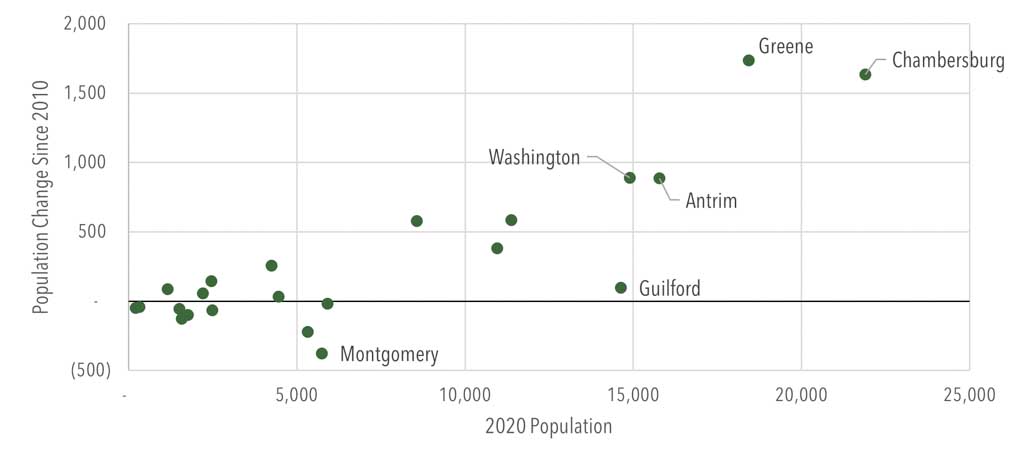
- Many Franklin County communities have been growing. In 2020, Greene Township recorded the highest population increase in absolute numbers, adding more than 1,700 new residents since 2010. Chambersburg Borough added an additional 1,635 residents (Figure 4).
- Orrstown Borough experienced the highest percentage of population loss over the past decade, with a loss of 18 percent (48 people). Warren Township had the next-greatest population loss over the same period with an 11 percent decrease (41 people).
- Population projections from the economic and demographic forecasting firm Woods & Poole estimate Franklin County’s population to grow to 191,022 in 2050 (Figure 3).
- By 2050, nearly a quarter of the county’s population (23.6 percent) is expected to be age 65 or older.
- In 2019, the county’s median age was 41.8 years, similar to Pennsylvania’s median age of 40.8 years.
Planning Implications
- As Franklin County’s population continues to grow, the transportation system will require additional services and capacity to accommodate greater demand for travel. This emphasizes the need to maintain transportation infrastructure in a state of good repair to support growth over time.
- Growth in the senior population translates to the need for more public transportation services and a highway system that is more predictable to use, with greater reflectivity, maintenance, and protection of traffic in work zones, and improved signage, among other considerations.
Socioeconomics
Overview and Key Trends
- Between 2014 and 2019, Franklin County’s total job count increased by 5.3 percent, adding more than 3,500 jobs over the five-year period. As of July 2022, the county had a labor force of 77,500. Woods and Poole forecasts show the county’s total employment reaching 115,337 by 2050.
- The county’s unemployment rate of 3.5 percent (July 2022) is the 11th-lowest in Pennsylvania.
- Just over half of Franklin County’s resident workers commute out of the county for employment, while the remaining 49 percent are employed within the county. Eighty-two percent of the county’s workforce commutes by driving alone. (Figure 5).
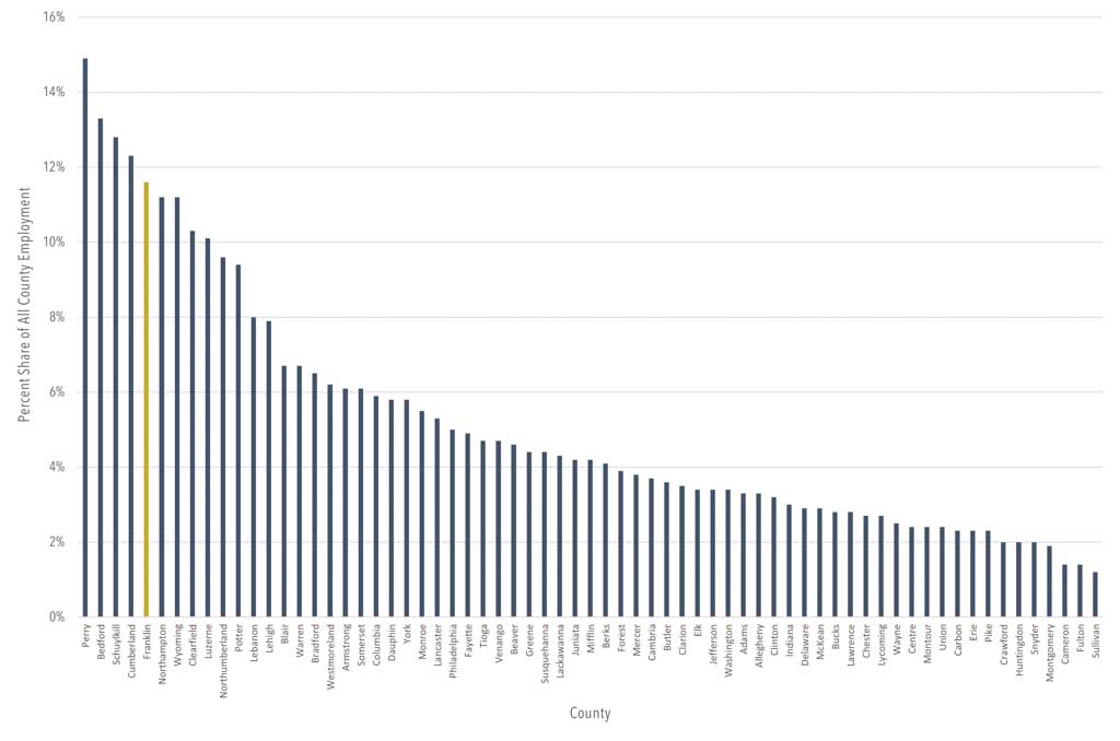
- Four major industry sectors account for more than half of Franklin County’s employment: Health Care and Social Assistance (16.7 percent), Manufacturing (15.6 percent), Retail Trade (12.2 percent), and Transportation and Warehousing (11.9 percent).
- The U.S. Government is the county’s top employer (Figure 6). In Greene and Letterkenny townships, Letterkenny Army Depot employs more than 3,600 people.
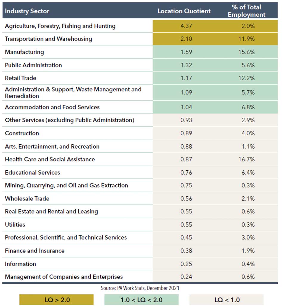
- Location Quotient (LQ) is a metric that compares an industry’s share of local-level employment to its share at the state level. An LQ greater than one indicates that an industry is a driver of local economic growth. In Franklin County, industries such as Agriculture, Forestry, Fishing and Hunting, Transportation and Warehousing, Manufacturing, and Public Administration are key economic drivers (Figure 7; Table 2).
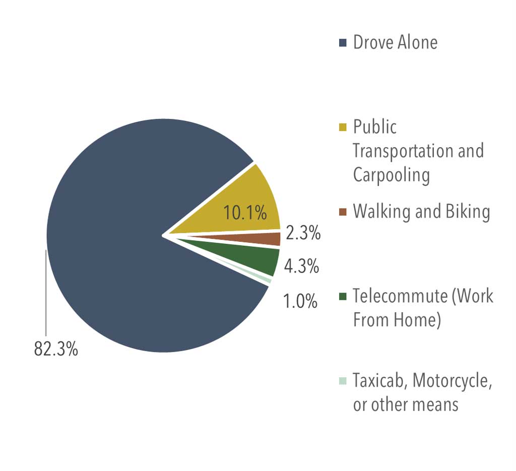
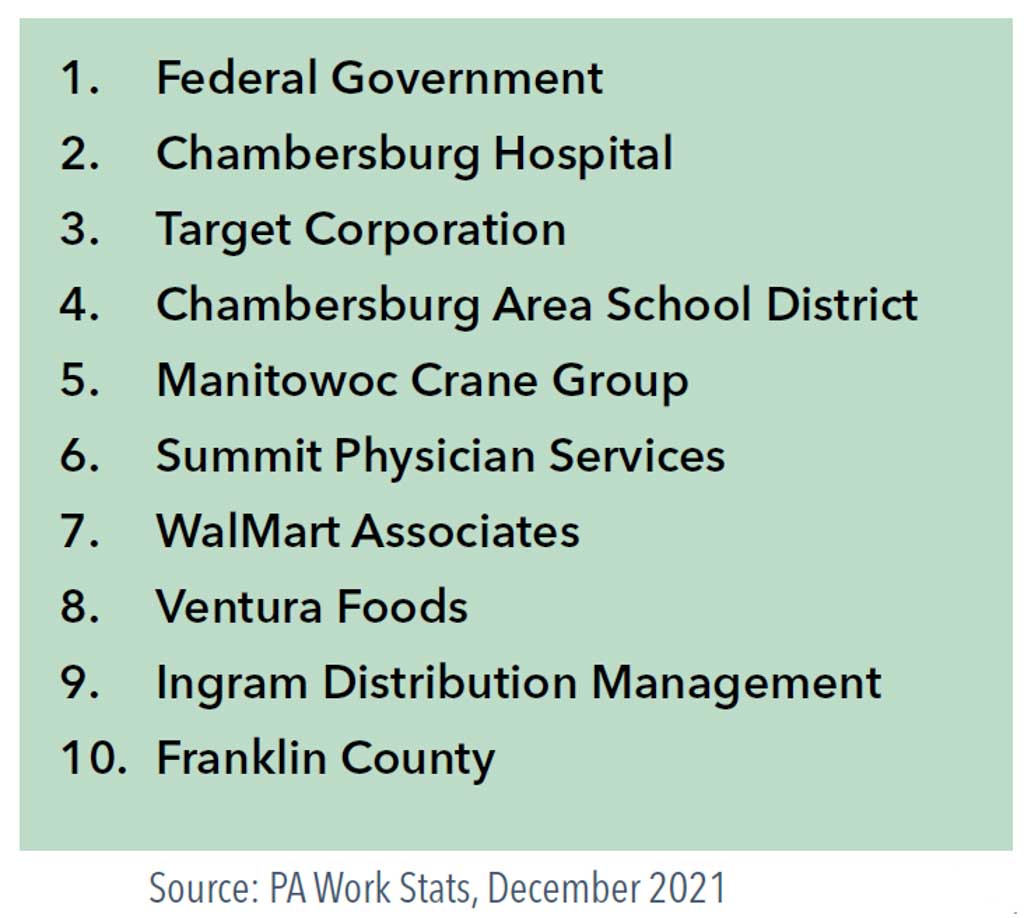
Figure 7: Transportation and Warehousing: Share of Total Employment by Pennsylvania County, 2019
Planning Implications
- As job growth continues, Franklin County will see increased demand on its transportation system as residents and commuters travel in and out of the county for work. This increase underscores the need to maintain state and local transportation infrastructure in a state of good repair to support growth over time.
Roadway Network
Overview and Key Trends
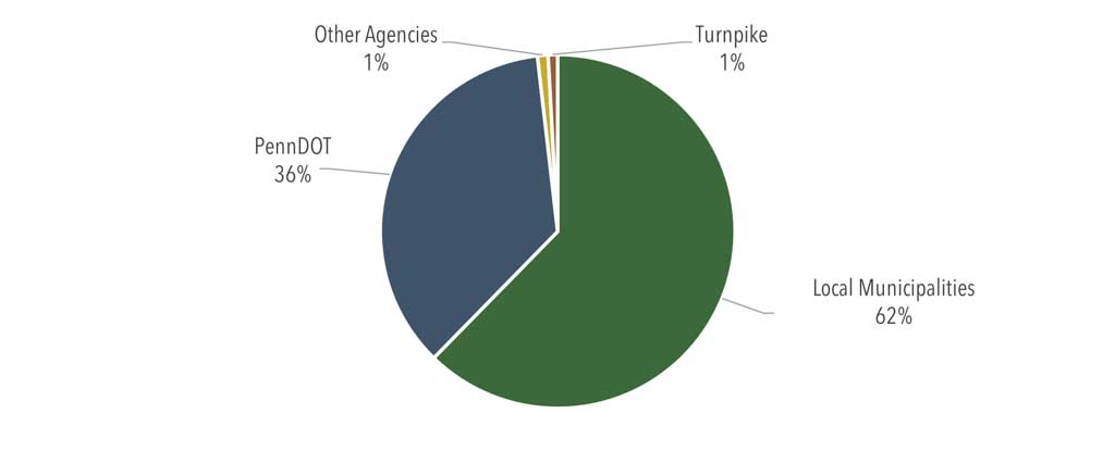
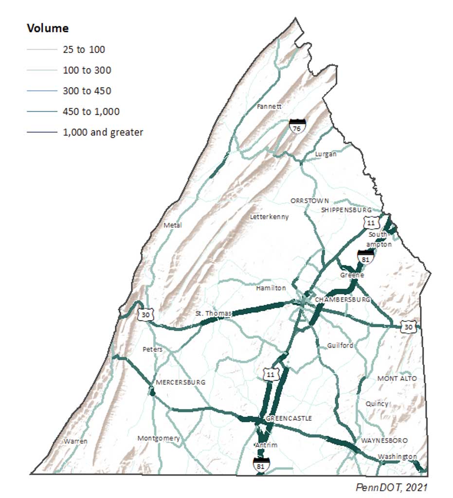
- Franklin County’s roadway system comprises more than 1,700 linear miles of roadway. While most of this mileage is locally owned (Figure 10), approximately 80 percent of travel is carried by state-owned roadways.
- Of the county’s roadway network, only 405 miles are on the Federal-Aid System.
- Interstate 81 constitutes only 25.8 linear miles of the county’s roadway network, yet it accommodates 43 percent of all travel, attesting to its strategic importance to the county’s mobility. Additionally, the roadway network includes 14.7 linear miles of the Pennsylvania Turnpike, including two interchanges at Willow Hill in Metal Township and Blue Mountain in Lurgan Township. These interchanges have the smallest volumes on the Turnpike system.
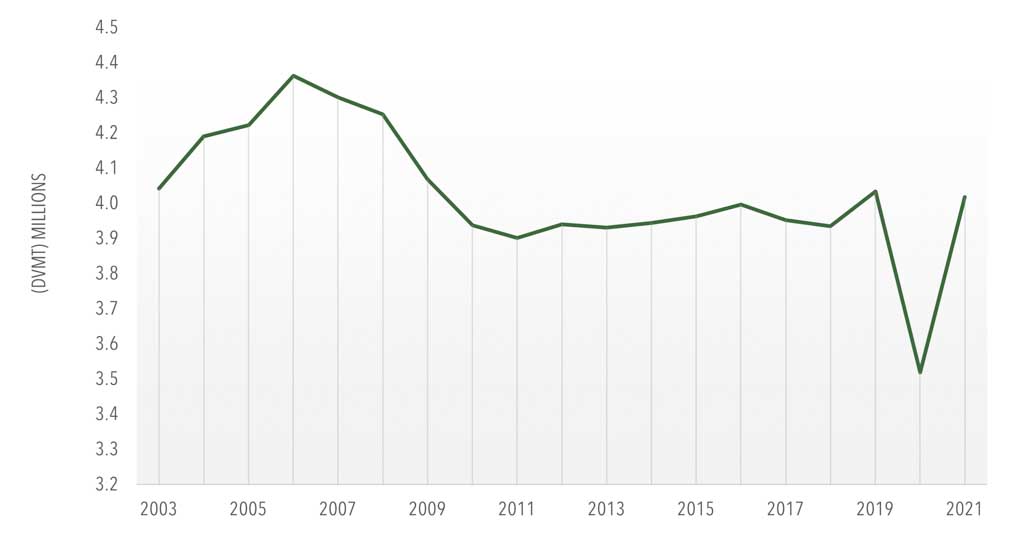
- Travel on Franklin County’s roadways has remained steady in recent years. For the decade ending 2021, the county’s roadway network carried an annual average of 3.92 million daily vehicle-miles traveled (DVMT). In 2020, travel demand in the county fell to 3.5 million DVMT, a 13 percent decline from the previous year due to the COVID-19 pandemic (Figure 11).
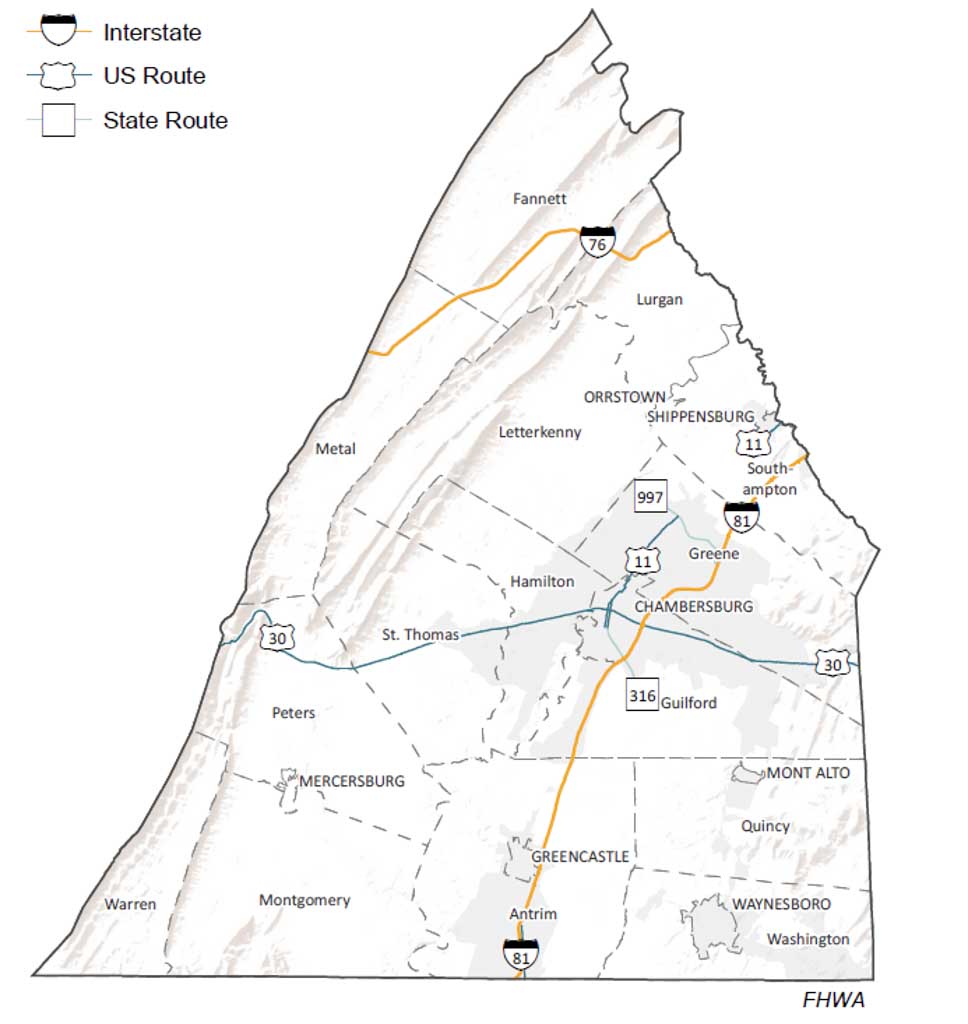
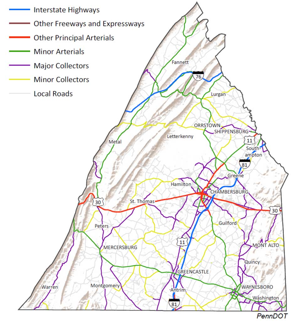
- The National Highway System (NHS) was established in 1995 to designate highways that are a vital priority for the nation’s economy, defense, and mobility. Within Franklin County, this network includes Interstates 76 and 81, US 30 in its entirety, PA 316 from US 30 to I-81, US 11 from US 30 to PA 997, and PA 997 from US 11 to I-81 (Figure 8).
- In February 2019, FHWA certified a portion of PA 16 as a Critical Rural Freight Corridor (CRFC). The certification makes PA 16 eligible for National Highway Freight Program funding, allowing the MPO to prioritize these dollars toward projects that will improve freight movement and efficiency.
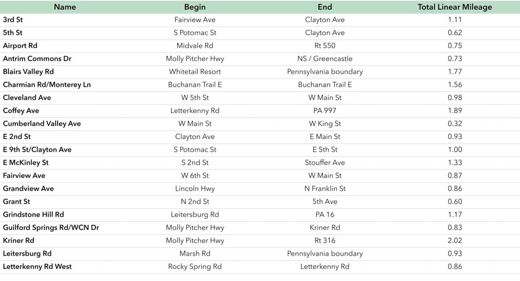
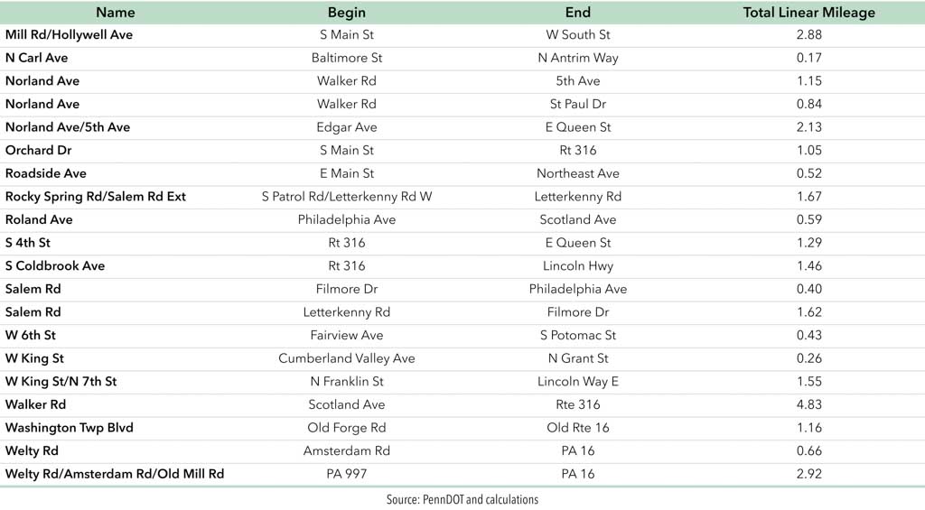
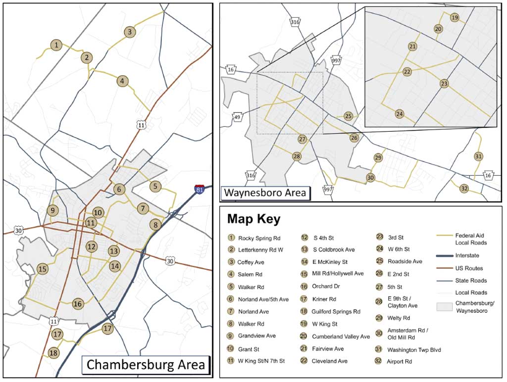
- There are 48.7 miles of locally owned, federal-aid-eligible roadway in the county. Notable examples include Kriner Road in Guilford Township (Figure 9). A complete list is available in Appendix G.
- There are currently no state or federally designated byways in Franklin County.
Planning Implications
- In a growing county such as Franklin County, the roadway network serves as the backbone of the transportation system.
- Understanding federal-aid requirements is critical in the delivery of federal-aid projects at the state and local levels. Municipal and state partners must work with the MPO, PennDOT, and FHWA to successfully manage locally administered federal-aid projects.
Functional Classification
Overview and Key Trends
- Functional classification represents an important nexus between transportation and land use.
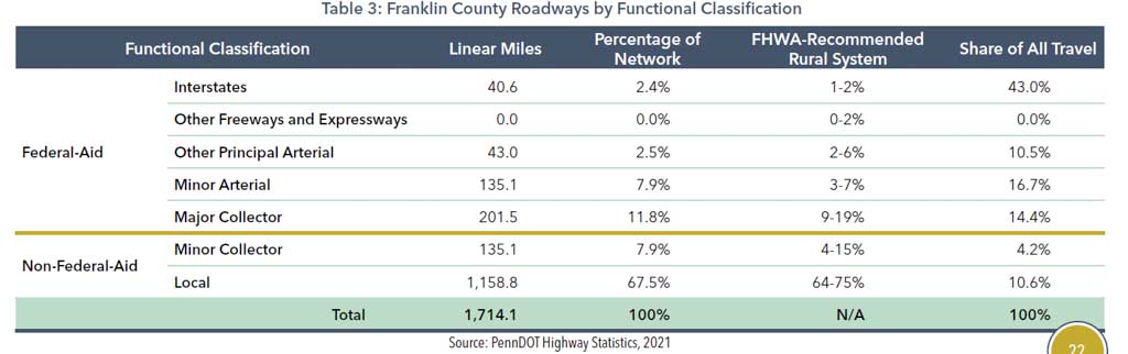
- Franklin County’s most recent functional classification update was completed in 2017. The existing classification scheme is closely aligned with federal recommendations for a rural system. The county continues to work closely with PennDOT to maintain roadway classifications (Figure 12; Table 3). Additional information regarding functional classification procedures can be found on PennDOT’s Traffic Information webpage.
- All roadways offer two primary functions: mobility (moving through an area efficiently) and accessibility (connections to residences, businesses, and workplaces). Interstates, for example, provide high mobility but low accessibility, whereas local streets primarily provide access.
Planning Implications
- Functional classification helps determine eligibility for many federal funding sources. The county’s average yearly share of National Highway Performance Program (NHPP) funding ($969,000) for the 2023 TIP period underscores the importance of keeping its functional classification system up to date to maximize federal funding potential.
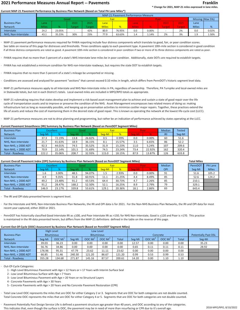
Roadway Conditions
Overview and Key Trends
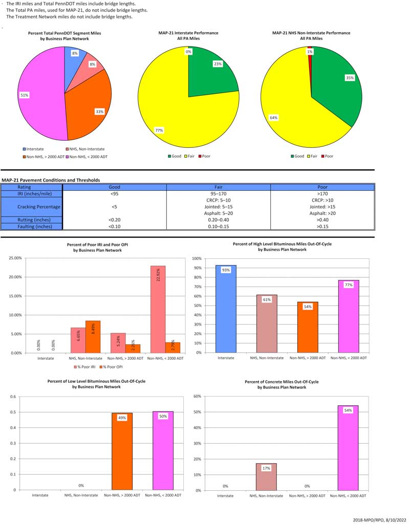
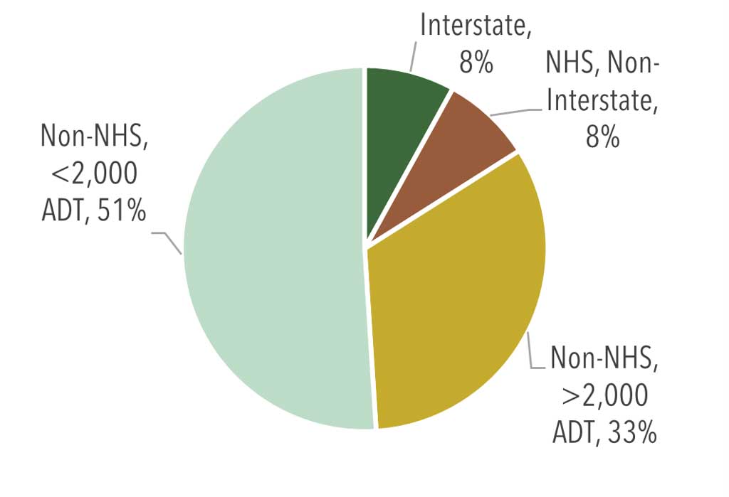
- PennDOT organizes the state’s roadways into four Business Plan Networks (BPNs): (1) Interstates; (2) NHS, Non-Interstate; (3) Non-NHS, > 2,000 Average Daily Traffic (ADT); and (4) Non-NHS < 2,000 ADT. Of these networks, more than half of Franklin County’s roadway mileage is comprised of BPN 4, Non-NHS routes with less than 2,000 ADT (Figure 13).
- The International Roughness Index (IRI) indicates the level of roughness of the pavement surface, while Overall Pavement Index (OPI) is a measure of a roadway’s pavement condition and how well a surface can carry stress.
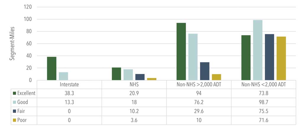
- When measured in IRI ratings, Franklin County’s pavements are in good condition with nearly 70 percent of all pavements rated “good” or “excellent.” This exceeds the statewide total of 56.6 percent. Roadways with “poor” IRI ratings in the county are commonly found on Non-NHS roadways with < 2,000 ADT (Figure 14 and Figure 15).
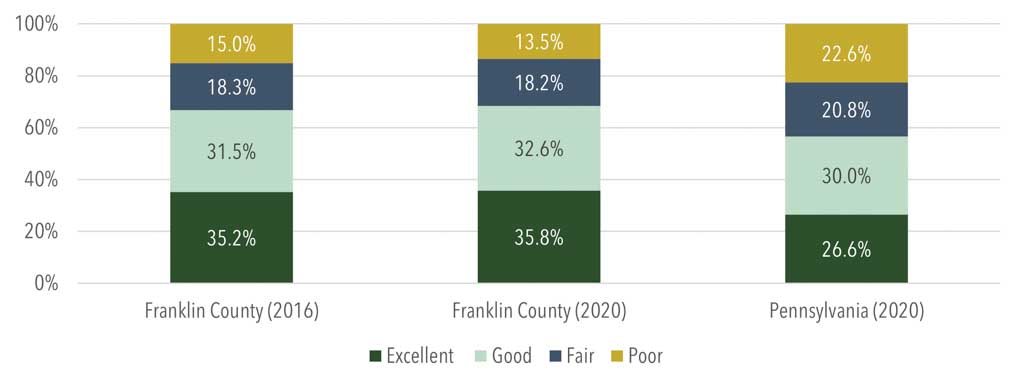
- When measured in OPI ratings, 80 percent of all pavements are in “good” or “excellent” condition; however, total “good” condition miles have worsened by 7 percent. Most of this mileage is now rated as “fair” condition. Interstates and NHS Non-Interstate routes have maintained excellent conditions in recent years, with the NHS (BPN 2) having the most mileage in “poor” condition (Figure 16).
Planning Implications
- Pavement conditions in Franklin County compare favorably to Pennsylvania statewide.
- While most pavements are in “good” to “excellent” condition, the trends indicate a greater need for roadway resurfacing on Non-NHS routes with < 2,000 ADT.
- Continued collaboration among Franklin County, PennDOT, and local municipalities is vital in identifying roadways on the transportation network in need of resurfacing, reconstruction, or preservation as pavements steadily deteriorate.
- PennDOT and the MPO promote a “lowest life-cycle cost” approach in addressing infrastructure condition. This approach puts greater emphasis on timely maintenance for system preservation. It not only extends the life of pavements and bridges, but it lowers the total cost of maintaining the asset.
Roadway Safety
Overview and Key Trends
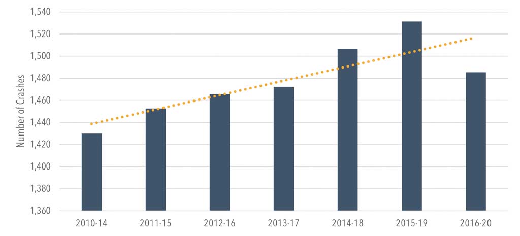
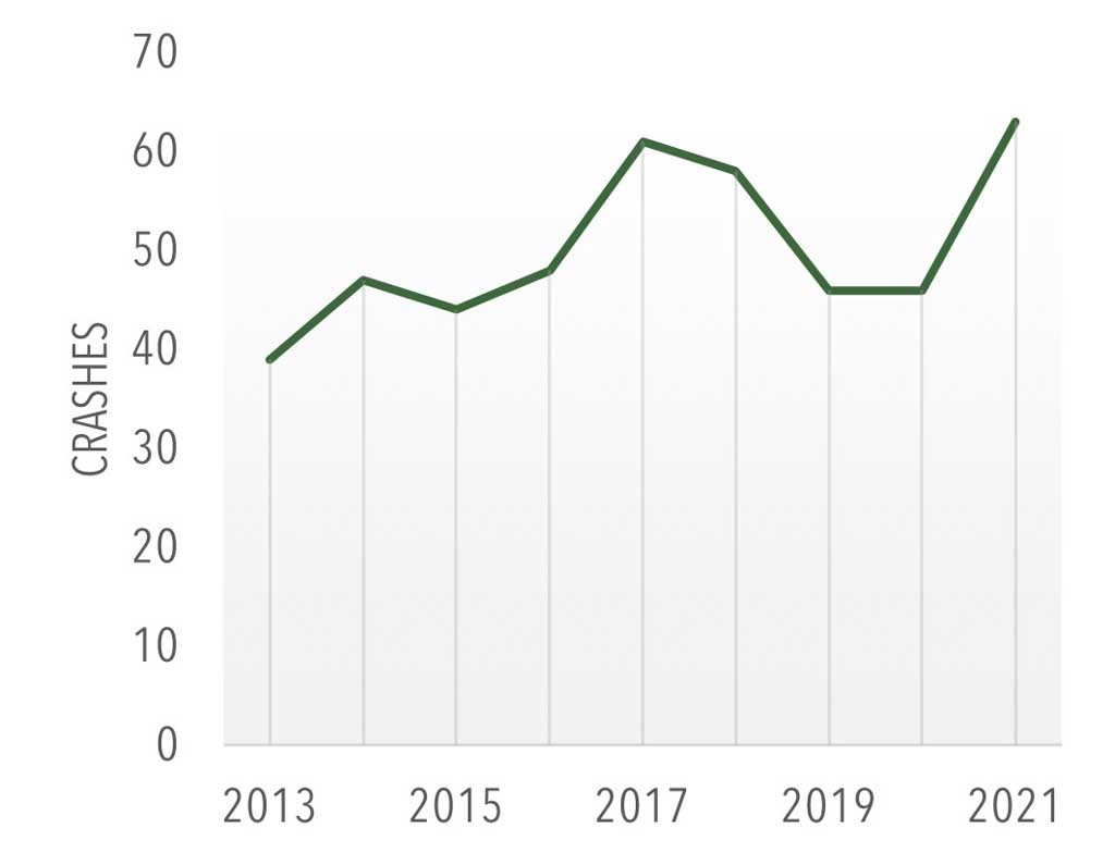
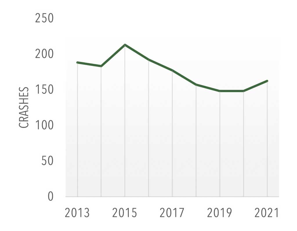
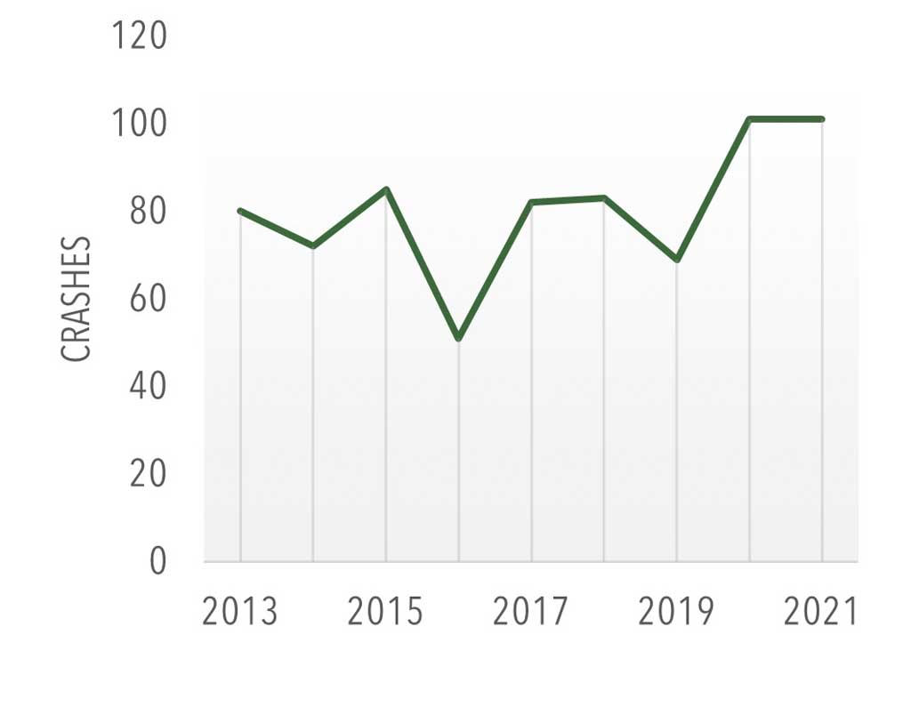
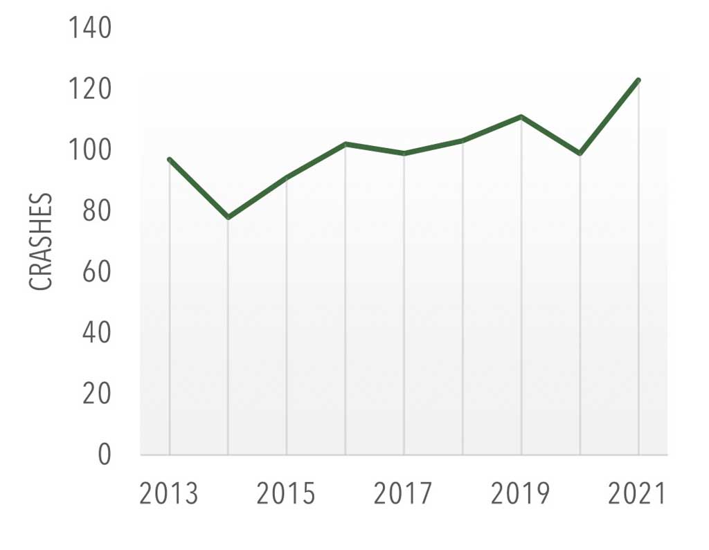
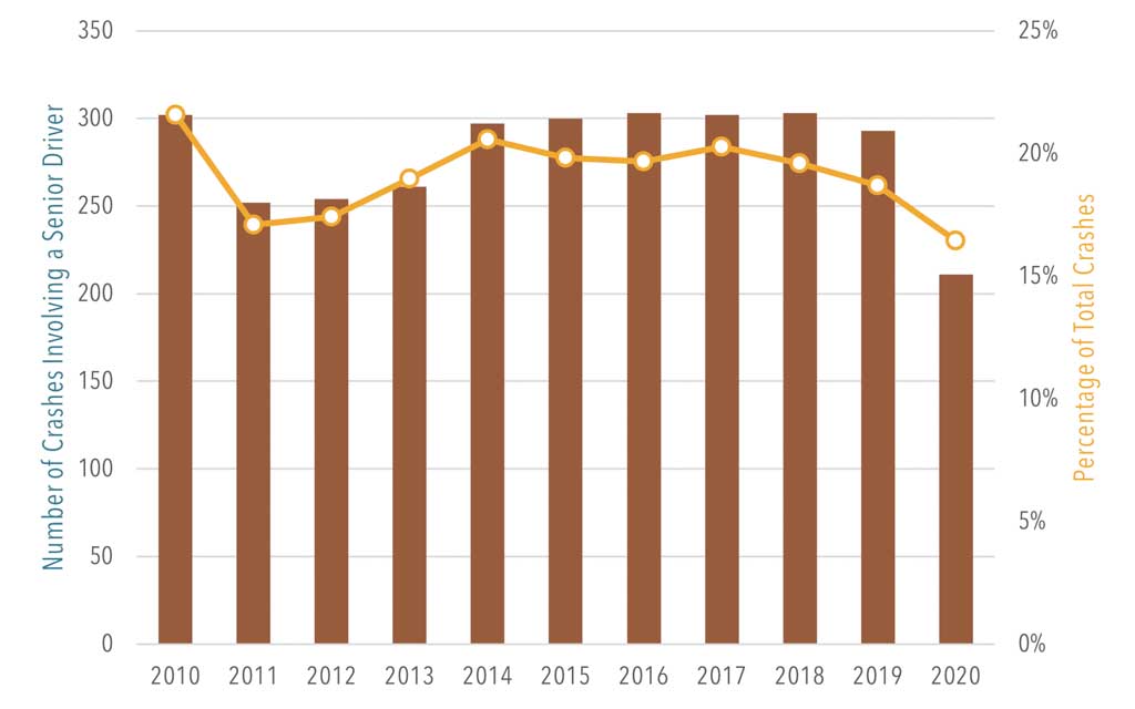
- For the five-year period ending 2021, Franklin County averaged 1,475 roadway crashes per year and 18 fatalities. The total number of annual crashes in the county has remained steady since 2010. Declines in total crashes and fatalities in 2020 are likely due to the reduced travel during the COVID-19 pandemic as a result of stay-at-home orders, business closures, and remote-work practices.
- Crashes involving those over the age of 65 have also remained steady—around 280 per year for the past five years. These crashes declined to an historic low of 211 in 2020, likely due to pandemic conditions (Figure 24).
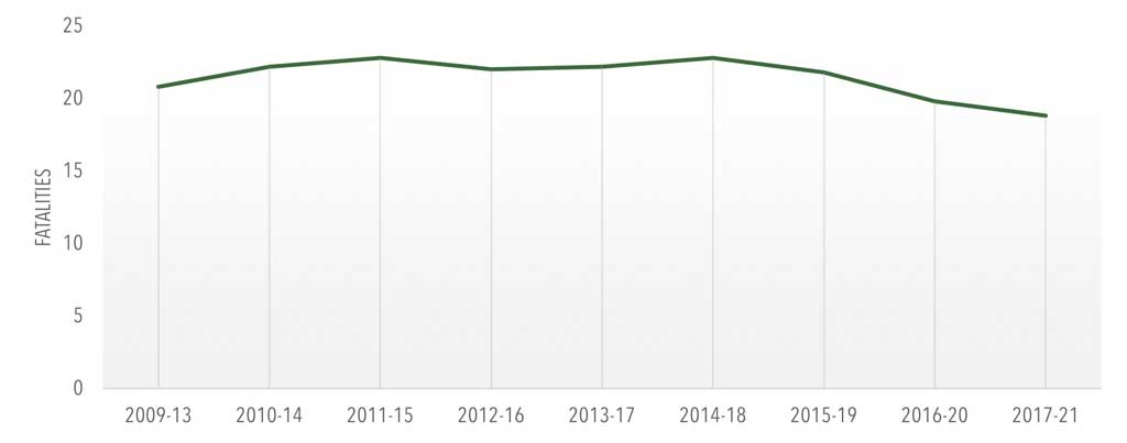
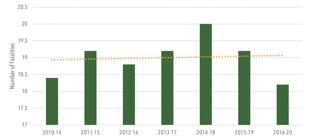
- For the decade ending in 2021, the county experienced an average of 20 roadway fatalities per year. The most common crash types involving fatalities were lane-departure crashes (10 annually on average) and run-off-the-road crashes (8 annually on average).
- Fatal crashes involving a driver age 65 or older were also among the more common crash types, averaging 7.5 annually over the past decade.
Planning Implications
- Safety continues to be a top priority for the Franklin County MPO and PennDOT. To support the national aspirational effort to eliminate traffic fatalities by 2050, PennDOT has committed to a goal of reducing crashes by 1 percent per year. Safety targets are calculated based on rolling five-year averages to better reflect trends. While annual crash totals have remained fairly steady, the county’s five-year average is trending upward despite a lower average in 2016-20. The five-year average trend for fatalities remains stable at 17.6 per year (Figure 19).
- Improved safety performance will require improvements in highway design, driver behavior, and enforcement mechanisms.
- Improvements in highway safety are not solely dependent on infrastructure improvements, but also on educational initiatives and the efforts of many organizations, as well as individual responsibility. This includes the safety of older drivers as Franklin County’s senior citizen population increases.
- In 2022, PennDOT revisited its safety performance targets for the next two-year reporting period. The MPO continues to have the option to adopt the targets set by the state to support the attainment of statewide and national highway safety goals
Interstate 81
Overview and Key Trends
- As one of the county’s two interstate highways, Interstate 81 (I-81) provides north-south mobility for both people and freight. It is a key asset that contributes to the county’s strategic geographic position, offering connections to other metropolitan areas, employment destinations, and markets in both Pennsylvania and Maryland.
- Approximately 43 percent of all travel that takes place within Franklin County occurs on I-81, attesting to its strategic importance.
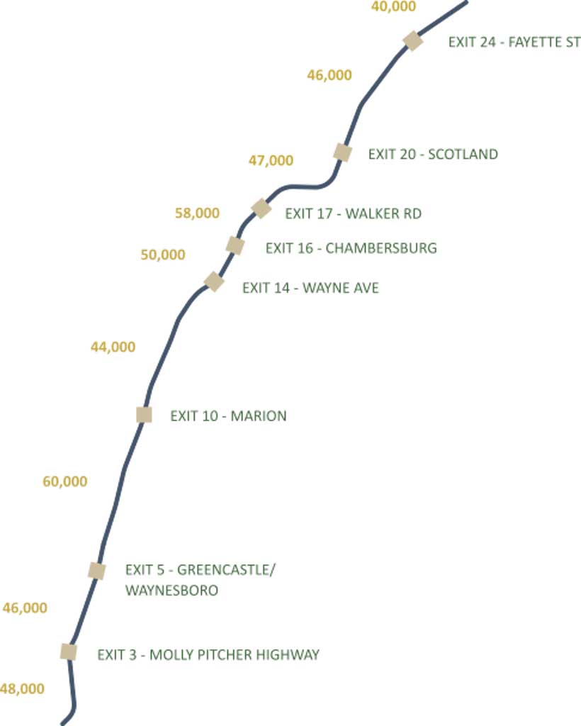
- Each day, an average of 54,000 vehicles travel on I-81 through Franklin County, and 29 percent of that traffic is heavy-vehicle traffic. According to PennDOT’s Traffic Information Repository, some segments of I-81 have nearly 40 percent truck traffic (Figure 26).
- The corridor continues to develop rapidly, largely consisting of commercial business parks and distribution centers. Interstate 81 provides ideal access to national markets and global gateways through its junction with the Pennsylvania Turnpike and major Class I rail lines. Many of the interstate’s interchanges “between the Potomac and the Susquehanna” now host distribution centers.
- The interstate has been the subject of considerable evaluation and study. A 2018 analysis of the broader corridor throughout the PennDOT District 8-0 region from the Maryland line through Lebanon County determined that a widening of the interstate to six lanes would cost more than $2.9 billion. Franklin County’s share of a proposed widening would be $848 million.
- The Franklin County MPO, in partnership
with PennDOT, FHWA, and neighboring
MPOs in Harrisburg and Lebanon County,
evaluated 100 miles of Interstate 81 for
safety, congestion, condition, and access
needs. The evaluation, known as the I-81
Improvement Strategy, identified the four-mile Greater Chambersburg Area segment
as one of the top four focus areas in the
corridor in need of improvement. This
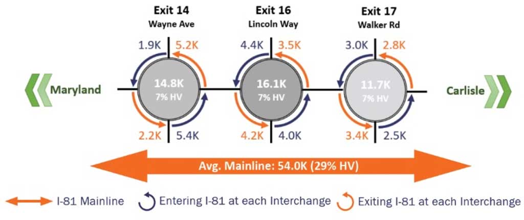
focus area included analysis of Exits 14
(Wayne Avenue), 16 (US 30 Lincoln Way),
and 17 (Walker Road):
- Exits 14 and 16 are experiencing ramp and ramp terminal (intersection) crashes in excess of similar roadways.
- Mainline I-81 routinely experiences minor travel delay between exits 14 and 16, which contributes to operations and safety concerns.
- Additional commercial and residential development near exits 14, 16, and 17 will increase traffic volumes at the interchanges.
- Existing pavement and structures along several segments of I-81 were constructed in the 1960s and are approaching the end of their serviceable life span.
- In 2020, PennDOT completed a Preliminary Alternatives Analysis of Exit 5 in Antrim Township to evaluate interchange improvement options to improve safety and traffic operations at the interchange and the PA 16 corridor. The study identified and evaluated eight conceptual alternative options, with four of them retained for detailed operational and safety analysis. It concluded that three out of the four studied alternatives would lead to operational and safety improvements in the area, including the relocation of the northbound exit ramps to Antrim Church or Grindstone Hill Road or reconfiguring to a Single Point Urban Interchange (SPUI).
- PennDOT has established a reserve line item of $225 million for I-81 Improvement Strategy Projects during the 2023 Twelve-Year Program’s (TYP’s) third four-year period (2031-34).
- There is currently $700 million in unmet rehabilitation and reconstruction needs annually on Pennsylvania’s interstates. PennDOT has planned a gradual increase in interstate funding over the next few years to meet federal bridge and pavement condition requirements. However, that will shift funding away from non-interstate highways and local roads.
- Moreover, there is an annual need of $1.2 billion statewide to meet cyclical asset management needs (routine maintenance to extend the life of interstate highways). The Commonwealth currently spends between $400 and $500 million per year on the interstate system. Interstate investment increased by approximately $150 million in FFY 2021 and will grow by $50 million a year until it reaches $1 billion in FFY 2028.
- Transportation electrification and use of alternative fuels are growing trends across the nation. PennDOT is in the process of developing an Alternative Fuel Corridor Deployment Plan for several interstate highway corridors, including I-81. As of early 2022, PennDOT identified I-81 through Franklin County as an alternative fuel corridor gap because there are no electric-vehicle charging stations. The nearest charging stations are located in Hagerstown and Carlisle. Pennsylvania will receive $170 million in federal dollars through FY 2026 to invest through the state’s plan for deploying electric vehicle infrastructure.
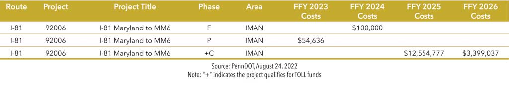
- PennDOT will resurface a portion of I-81 from the Maryland line to Mile Marker 6 within the first four years of the 2023 TYP as part of a $16 million project.
- Over the past five years (2016-20), there have been a total of 631 crashes along the interstate in Franklin County. Of these crashes, there have been eight fatalities and 150 suspected injuries (30 severe, 120 minor).
Planning Implications
- As more warehousing and distribution centers are constructed in Pennsylvania, Franklin County can expect more commercial vehicles on the road, particularly on I-81 and surrounding interchange areas. This growth will require strategies to help manage freight traffic, such as additional parking areas.
- Emerging technologies will transform transportation over the next 20 years. Not only will local planning organizations need to prepare for connected and autonomous vehicles, but other technologies, including electric vehicles and delivery drones, will need to be considered in the planning process.
- The proliferation of probe vehicle data, such as INRIX and WAZE, has allowed transportation agencies to identify congestion hot spot areas easily and efficiently. PennDOT purchases vehicle speed data for all state-owned roadways, and Franklin County has access to this data.
- PennDOT’s Interstate Steering Committee will draw from the recently completed I-81 Improvement Strategy as it maintains a statewide Interstate TIP.
- Formula funds from the 2021 Bipartisan Infrastructure Law (BIL) added programming capacity for 15 new projects to the MPO’s TIP. Although PennDOT manages the Interstate TIP, these new funds provide an opportunity for the Franklin County MPO to invest in improvements on lower-tier roadways and bridges adjacent to I-81, improving system efficiency and highway safety.
- At the time of this plan’s development, a new interchange at Guilford Springs Road (Exit 12) was in final design. While this new interchange was not included in the I-81 Improvement Strategy, it is being designed to improve truck access and vehicle flow from existing and future industrial development in the area. The MPO will continue to monitor progress on the project as it moves toward construction.
Traffic Operations
Overview and Key Trends
- The role of planning for traffic operations continues to expand, with the increasing demand for travel along with limitations to funding for the transportation system’s maintenance and operation. Since 2007, PennDOT has formally developed and maintained a Regional Operations Plan (ROP) to guide planning for transportation systems management and operations (TSMO). TSMO aims to improve operations, including traffic flow, thereby maximizing the capacity of the existing system.
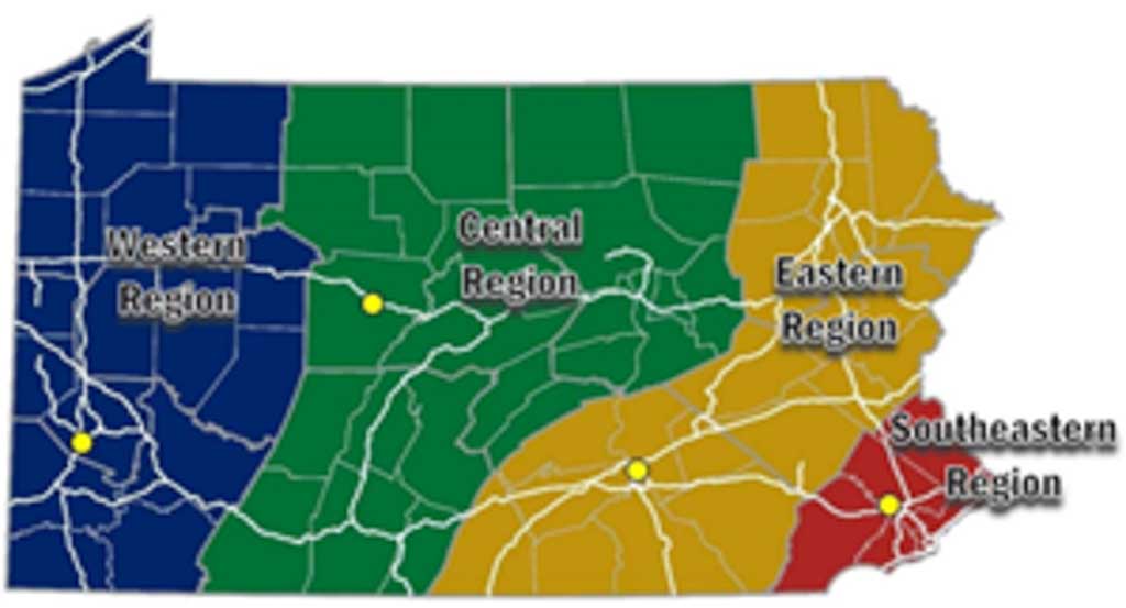
- As part of this effort, PennDOT has organized the state into four planning regions. Franklin County is situated within the Eastern Region of PennDOT’s TSMO network (Figure 27). In most cases, TSMO improvements cost less than traditional roadway expansion projects and can be implemented in a much shorter time frame. These low-cost improvements yield a high return on investment and can directly target problem areas.
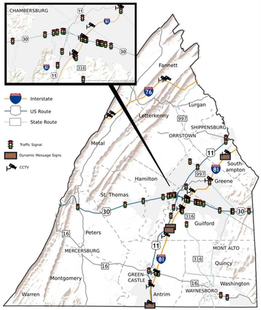
- Example TSMO improvements include re-timing traffic signals to reduce congestion at signalized intersections, installing closed-circuit television (CCTV) cameras to monitor roadway conditions, and implementing Dynamic Message Signs (DMS) to disseminate traveler information.
- There are 121 traffic signals, 13 CCTV cameras, and four DMS located in Franklin County. Forty percent of the county’s traffic signals are located in Chambersburg Borough (Figure 29). Traffic signals can improve the safety and efficiency of roadway networks for motorists as well as for transit, cyclists, and pedestrians. However, poor signal timing and/or poor coordination between signalized intersections can negatively impact traffic flow and the effectiveness of the signals.
- PennDOT owns and maintains park-and-ride lots adjacent to two interchanges along I-81: at Exit 20 in Greene Township and Exit 24 in Southampton Township. Both lots are accessible via PA 696.
- A law enacted in July 2022 provides an additional $5 million in grants to municipalities to install and maintain traffic signal technologies as part of the Traffic Signal Technologies Grants Program, which will be administered as a supplemental round under the Green-Light-Go Program.
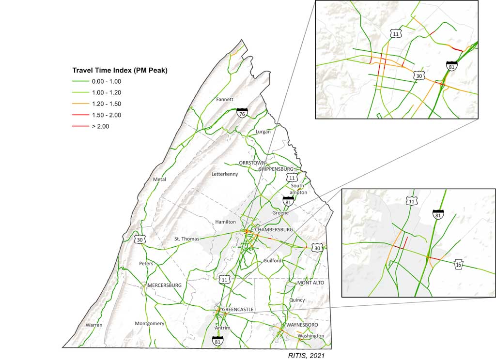
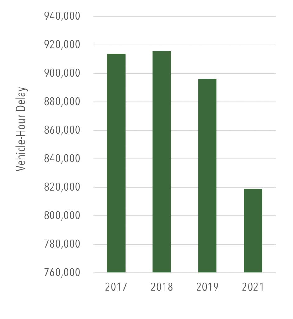
- Data from RITIS reveal that motorists on Franklin County’s roadways experience more than 800,000 vehicle-hours of delay per year (Figure 31). This is an improvement over pre-COVID data but still translates into lost productivity, increased opportunity costs, and diminished quality of life.
Planning Implications
- Investments in traffic operations often yield a greater value per dollar spent versus capacity-adding projects, making operations a key area of focus for the MPO.
- While congestion may be decreasing somewhat due to a lessening demand for travel due to the pandemic and its aftermath (e.g., increase in telework, etc.), there are opportunities to address bottlenecks and congestion through the TSMO strategies identified by PennDOT in collaboration with the MPO.
- While the MPO is not required by FHWA to administer a Congestion Management Process (CMP), the availability of new crowd-sourced tools and data sources still allow the MPO to focus on the county’s worst hot-spot locations for bottlenecks and congestion as part of its work program.
- The MPO can assist municipalities with improvements related to efficiency and operation of traffic signals by guiding them to funding programs such as Automated Red Light Enforcement Funding Program (ARLE), Green LightGo, and the new Traffic Signal Technologies Grants Program created by Act 54 of 2022.
- Franklin County’s ongoing participation in Commuter Services of Pennsylvania will aid workers and others in finding alternatives to traveling via single-occupant vehicle.
- Through its ROP, PennDOT has noted
several TSMO-related planning needs in
Franklin County, including:
- The US 30 corridor through Franklin, Adams, and York counties is in need of Traffic Incident Management (TIM) during incidents.
- Freeway Service Patrols on I-81/US 30.
- Signal improvements on PA 16, Main Street in Waynesboro, for equipment upgrades and re-timing.
- Deploying CCTV and DMS to fill gaps in coverage.
- The US 30 corridor has been identified as a candidate for inclusion in a statewide fiber optic network.
- An Eastern Region Traffic Management Center Truck Parking Study is recommended to determine needs and locations for possible expansion of truck parking.
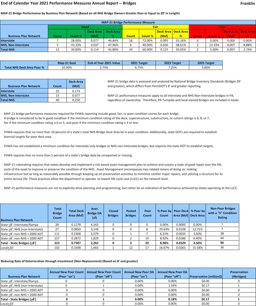
State-Owned Bridges
Overview and Key Trends
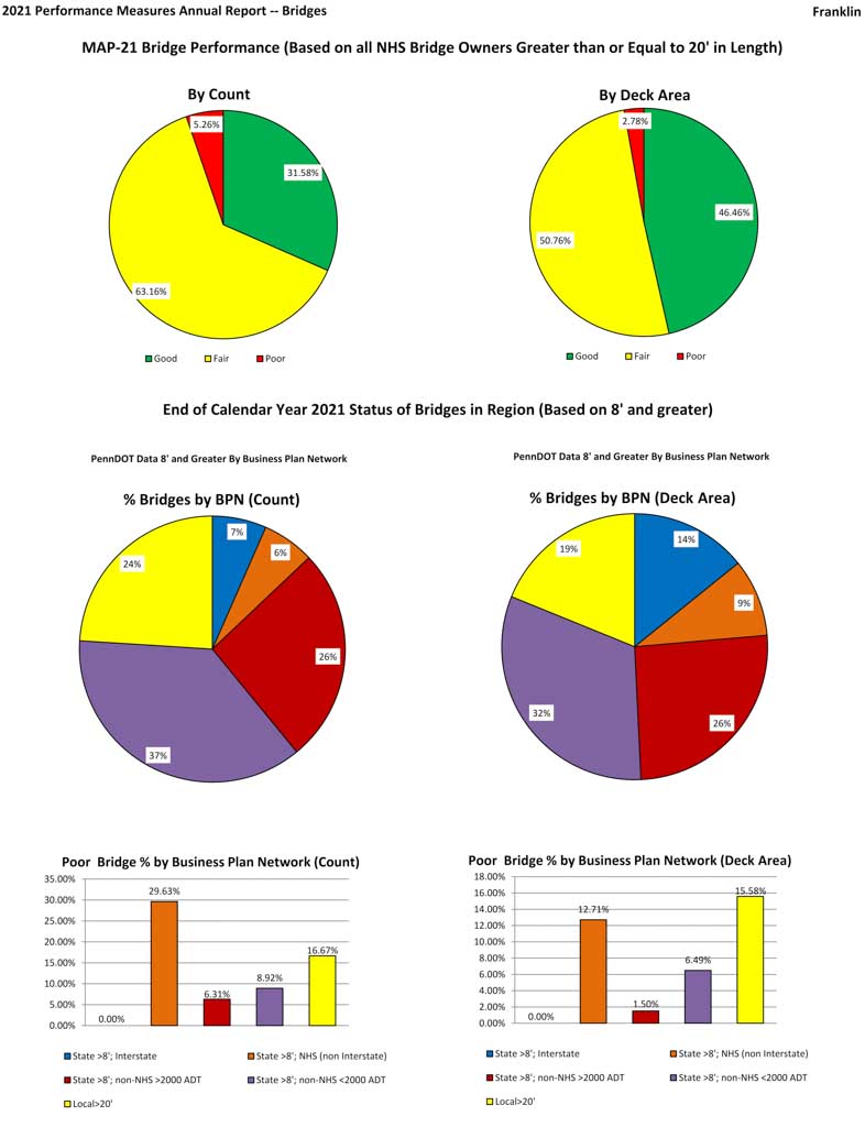
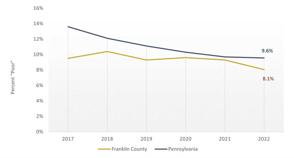
- There are 323 state-owned bridges greater than 8 feet long in Franklin County. Of these structures, 26 (8.1 percent) are rated as being in “poor” condition (Table 5). This aligns closely to the state average of 9.6 percent. The total number of bridges rated in “poor” condition has improved over the last five years (Figure 33).
- A meaningful measure of bridge condition is the share of bridge deck area considered in “poor” condition. The bridge deck area refers to the roadway surface that spans the length of the bridge. Within Franklin County, this rate is 4.3 percent, slightly better than the state average of 5.5 percent.
- Of these structures, three are posted (weight-restricted), while none are closed.
- The average age of state-owned bridges in Pennsylvania is 55. In Franklin County, the average age is 63 (Figure 32). Most bridges have a design life of approximately 50 years.
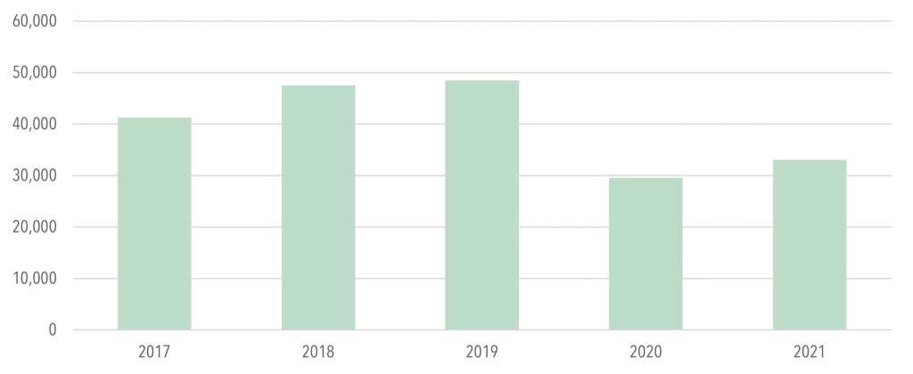
- Bridge construction activity over the last decade has doubled, adding 31 new bridges between 2011 and 2021. This is compared to just 16 newly constructed bridges in the decade prior.
- The MPO has $5.8 million available in state bridge funding as part of its 2023 TIP. Bridge dollars are commonly allocated based on the county’s share of the state’s total deck area.
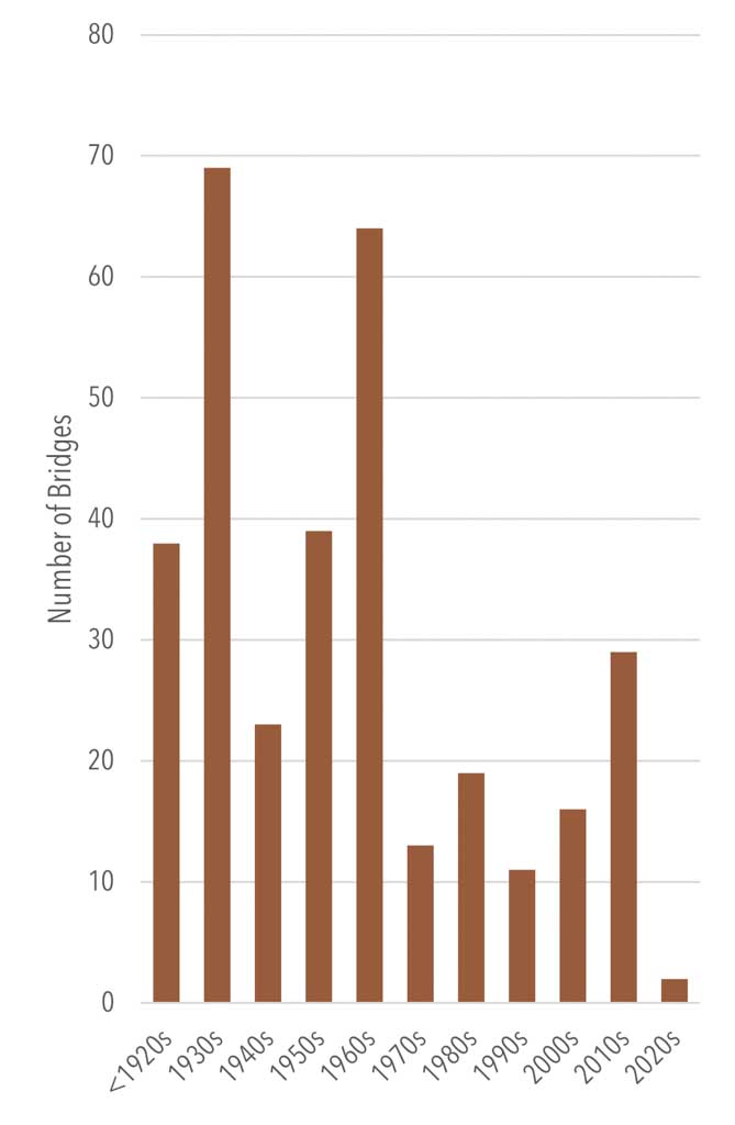
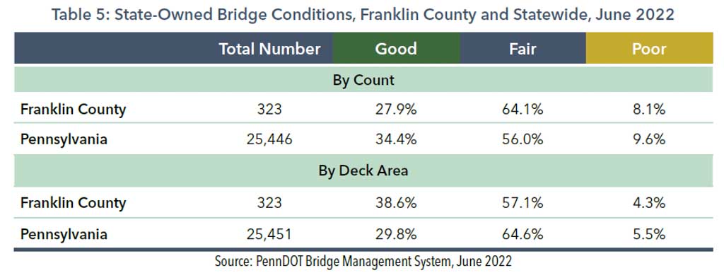
Figure 33: Percentage of State-Owned Bridges Rated “Poor,” Franklin County and Statewide, 2017-21
Planning Implications
- Recent warehousing developments and increased truck traffic may accelerate deterioration of the county’s transportation assets. As truck sizes get larger and carry heavier loads, bridges may need additional preservation, rehabilitation, or repair.
- As the bridge inventory continues to age, the county will be faced with a greater stock of bridges in need of maintenance or rehabilitation attention. Depression-era bridges (built in the 1930s) comprise 21 percent of the county’s bridge stock and will need to be replaced.
Local Bridges
Overview and Key Trends
- PennDOT’s Bridge Management System (BMS) notes that there are 102 total locally owned bridges greater than 20 feet long throughout Franklin County. Of these structures, one is closed and 14 are posted.
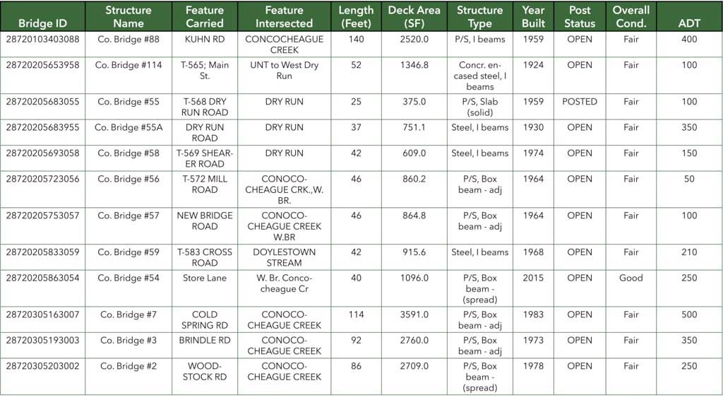
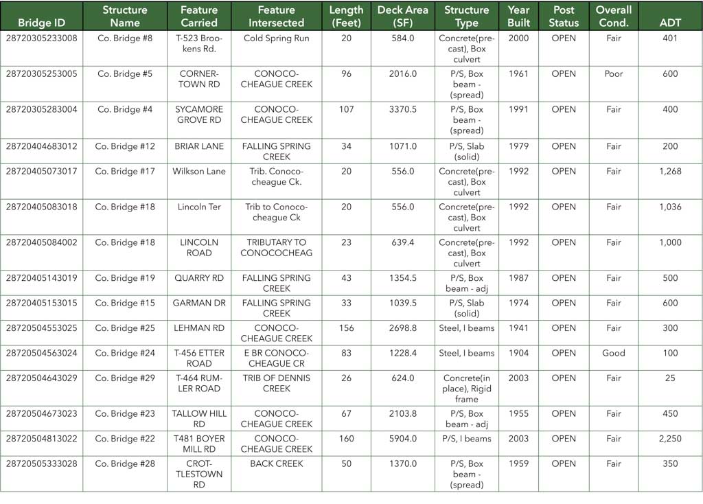
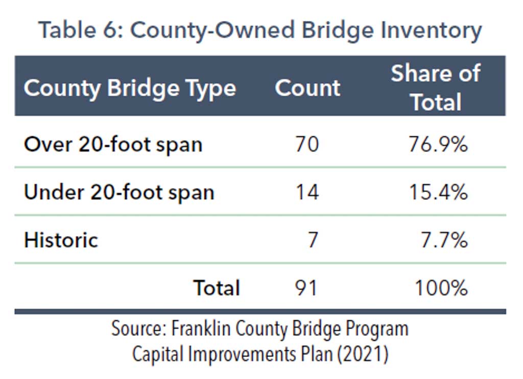
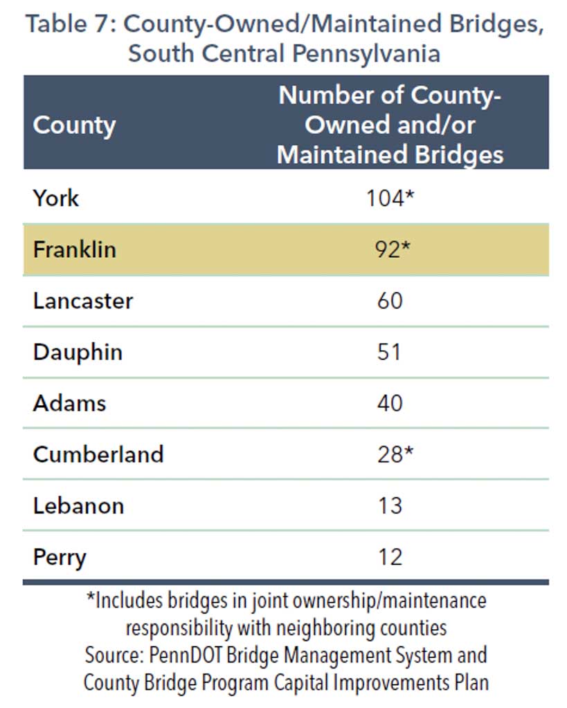
- Franklin County owns and maintains 92 local bridges, including 7 historic bridges (Figure 35, Table 6). When compared to other counties in South Central Pennsylvania, Franklin County owns and maintains the second-highest number of bridges in the region, just behind York County (Table 7).
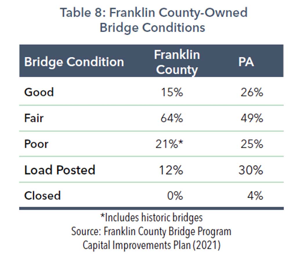
- More than 60 percent of county-owned bridges are currently in “fair” condition. This exceeds the Pennsylvania state average of 49 percent. The number of county-owned bridges rated in “good” condition (15 percent) falls below the statewide average (26 percent) (Table 8).
- The share of “poor” condition, locally owned bridge deck area in Franklin County is 16 percent, better than the state average of 21.7 percent as reported by BMS.
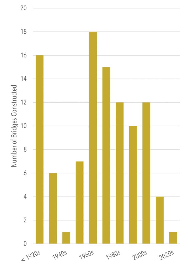
- Franklin County’s local bridge stock has an average age of 59, with nearly 18 percent of bridges constructed in the 1960s (Figure 34).
- Counties receive a portion of Liquid Fuels funding, as based on the original allocation established by the Liquid Fuels Act of 1931, which allocated one-half cent of fuel tax to counties. Distribution is based on each county’s fuel consumption in the years 1927, 1928, and 1929 relative to statewide consumption in those years. An additional $5 million allocation was authorized by Act 44 of 2007 and is based on the ratio of square foot deck area of a county’s owned bridges to the total statewide deck area of county-owned bridges.
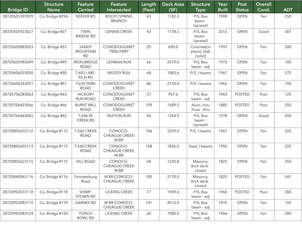
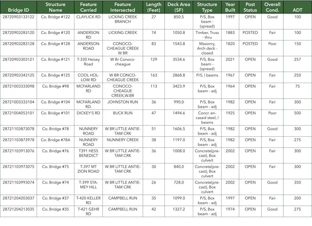
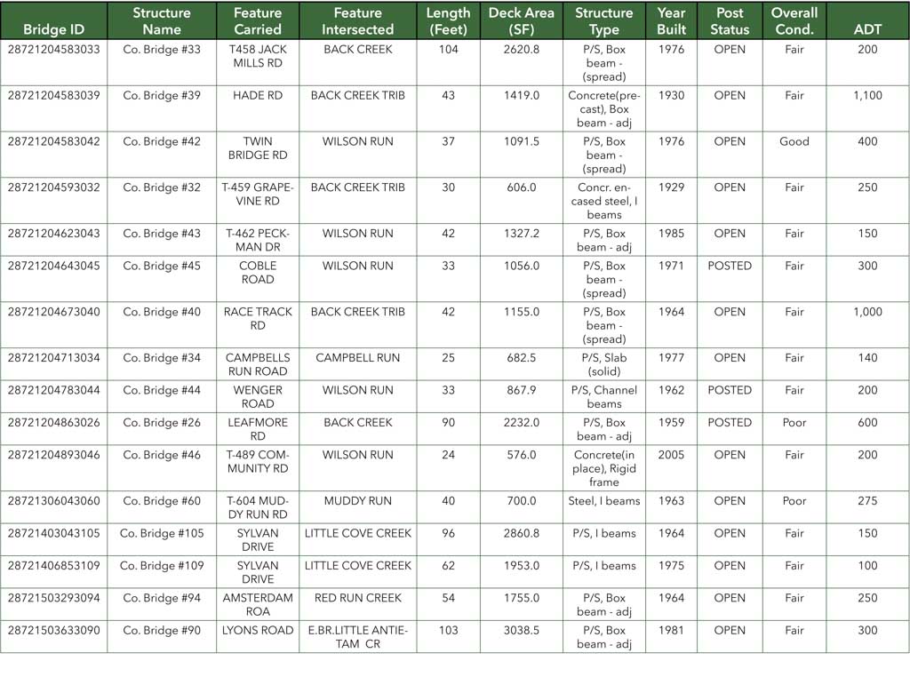
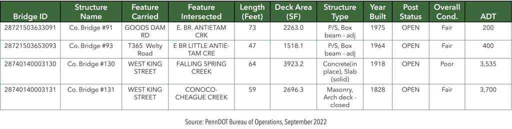
- A listing of all county-owned bridges is provided in Appendix F.
Planning Implications
- Local bridges are commonly ineligible for federal transportation funds, except for the Off-System Bridge Program (currently valued at $3.4 million over the life of the MPO’s 2023 TIP) for local bridges greater than 20 feet in length. This program establishes criteria for funding improvements to bridges that are not on the Federal-Aid System. The MPO has moved to suspend the required 5 percent local match for the 2023-26 TIP period, which will lessen the administrative challenges related to reimbursement agreements and allow the MPO to redirect state funding to other projects. The decision was based on guidance provided by FHWA in response to the Infrastructure Investment and Jobs Act of 2021.
- Act 89 of 2013 authorized counties to levy an optional $5 fee on vehicle registrations, which can be used for the construction, reconstruction, maintenance, and repair of public highways and bridges. (For Franklin County, this would translate into approximately $870,000 in annual revenue.) Although Franklin County has not enacted the $5 fee, it leverages other finance strategies to support local and county-owned bridges.
- Many of the bridges owned and/ or maintained by Franklin County are reaching the end of their design life. These structures will need to be considered for preservation, rehabilitation, or replacement to avoid closure. Extended bridge closures can impact overall network connectivity for both passenger and goods movement.
- Franklin County will continue to assist its local government partners in identifying funding sources to address local bridge needs.
Public Transportation
Overview and Key Trends
- Franklin County does not have countywide fixed-route public transportation service. Capital Area Transit (CAT) provides fixed-route service in Shippensburg and has one Saturday route that runs from Shippensburg to Chambersburg Crossing Shopping Center.
- Shared-ride services are available for approved individuals through rabbittransit (Figure 36). Additionally, rabbittransit provides transportation for veterans through its Veterans Employment Transportation Program.
- PennDOT owns and maintains park-and-ride lots adjacent to two interchanges along I-81 in Franklin County: at Exit 20 in Greene Township and Exit 24 in Southampton Township. Both lots are accessible via PA 696.
- rabbittransit is collaborating with Franklin County on a three-year pilot for micro-transit service in the Greater Chambersburg area. The new service, which had its first full month in September 2022, fills gaps in traditional service modes and is powered by a zone-based mobile app.
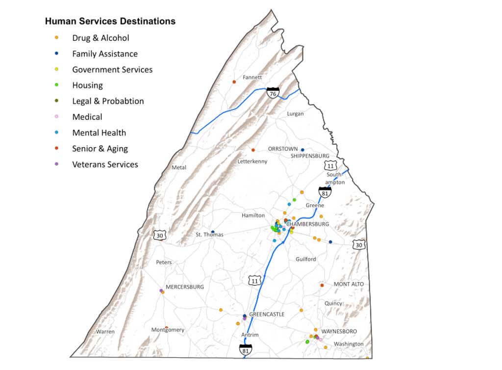
- The MPO completed an update of its Local Coordinated Human Service Transportation Plan in September 2021. Key stakeholders provided the foundation for updating the transportation inventory, identifying key destinations in the region, defining human service transportation challenges, and developing strategies to improve options for citizens receiving services within the county (Figure 37).
Planning Implications
- Public transportation provides mobility services for those who choose to ride, do not own a car, or are unable to drive. A reliable and efficient system that connects to businesses, employers, recreation, and natural areas can support economic development and help attract new residents and businesses.
- Franklin County will continue its efforts to increase alternative modes for multimodal transportation and complete trip planning. Integrating transit, transportation demand management (carpooling and vanpooling), and bicycle and pedestrian accommodations and increasing the reliability and timeliness of services are examples of strategies that can contribute to increased ridership.
- In urbanized areas such as Chambersburg, the availability of public transportation correlates with reduced traffic congestion and improved air quality.
- The MPO is seeking to partner with its counterparts within PennDOT District 8-0 in the development of a comprehensive, multi-county human service transportation plan. Planning at this scale could create opportunities for transit connections that cross regional boundaries and may increase grant funding potential.
- Most users of shared-ride service are senior citizens and persons with disabilities (PwD). As the county’s population continues to age, there will be higher demand placed on public transportation services to promote mobility and maintain a high quality of life.
Rail Freight
Overview and Key Trends
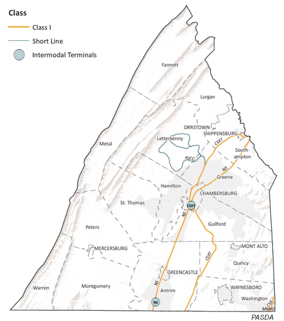
- Two Class I railroads operate in Franklin County: CSX Transportation (CSX) and Norfolk Southern (NS) (Figure 39). Both offer north-south connections, operating parallel to Interstate 81.
- There are no Class II railroads in Franklin County.
- Two Class III “short-line” railroads operate within the county, including the Pennsylvania and Southern Railroad (PSCC) and the Maryland Midland Railway (MMID).
- PSCC operates on the 38 miles of trackage owned by the Franklin County General Authority. Most of this network is in the Chambersburg area, primarily within the Letterkenny Army Depot. Key commodities transported by PSCC include aggregates, agricultural products, chemicals, food, metals, plastics, timber, automobiles, and heavy machinery.
- MMID operates 81 miles throughout Maryland, with only 0.4 miles passing through Franklin County. Connections to CSX are available in Maryland. Key commodities transported by MMID include aggregates, chemicals, and timber and related products.
- Franklin County has two major intermodal terminals that support goods movement transfers between rail and truck. Since 2007, CSX has operated an 85-acre intermodal terminal in Chambersburg while NS offers intermodal connections at its 200-acre Greencastle Intermodal Yard, located in Antrim Township and part of the railroad’s “Crescent Corridor.” CSX’s existing terminal in Chambersburg is part of its multimillion dollar “National Gateway,” a double-stack corridor to improve shipping between the East Coast and the Midwest through a public-private partnership.
- The Greencastle Intermodal Yard suspended operations in 2019 but reopened in September 2021 due to accelerating e-commerce growth and COVID-19 pandemic recovery. NS experienced pandemic-related traffic declines which has included a collapse in coal volume, but the railroad is now moving more tonnage on fewer, longer trains.
- NS is exploring the concept of carrying more loads that could be moved via either truck or rail (known as “flexible freight”) through its “Thoroughbred Freight Transfer” program as a way of converting more “less-than-truckload” truck traffic to rail.
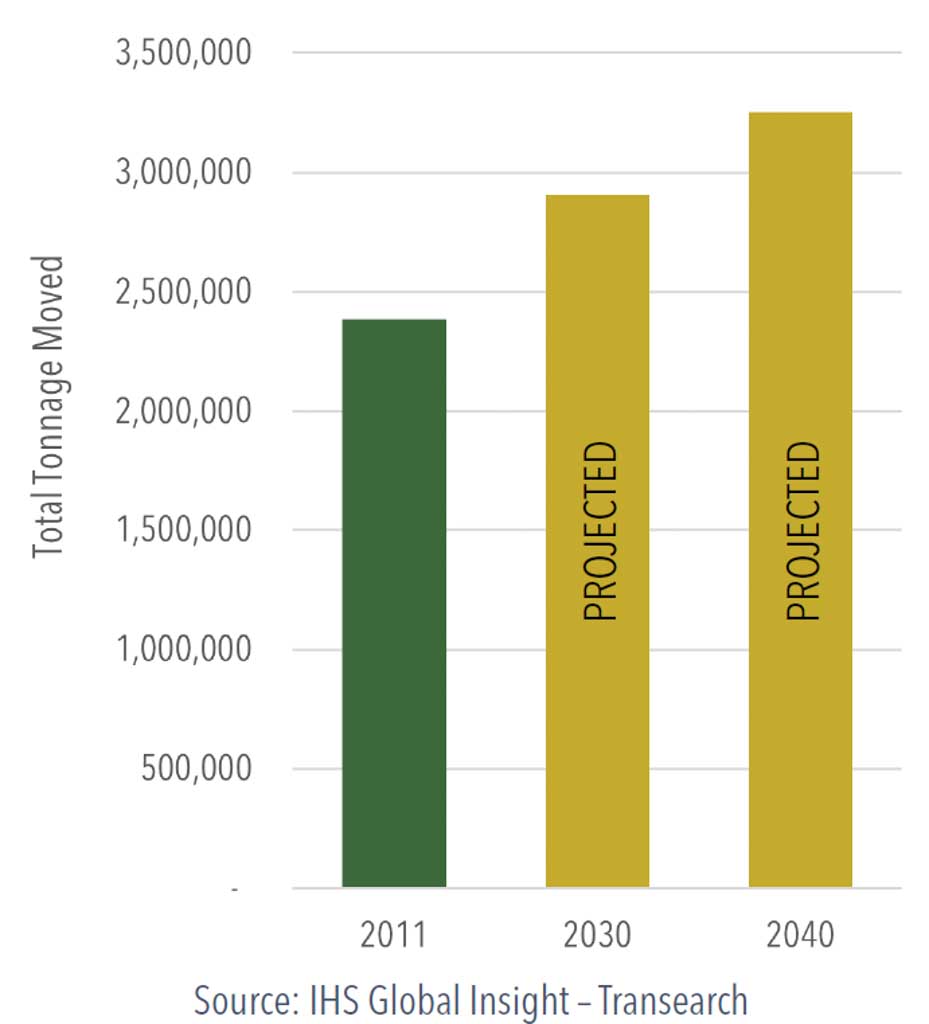
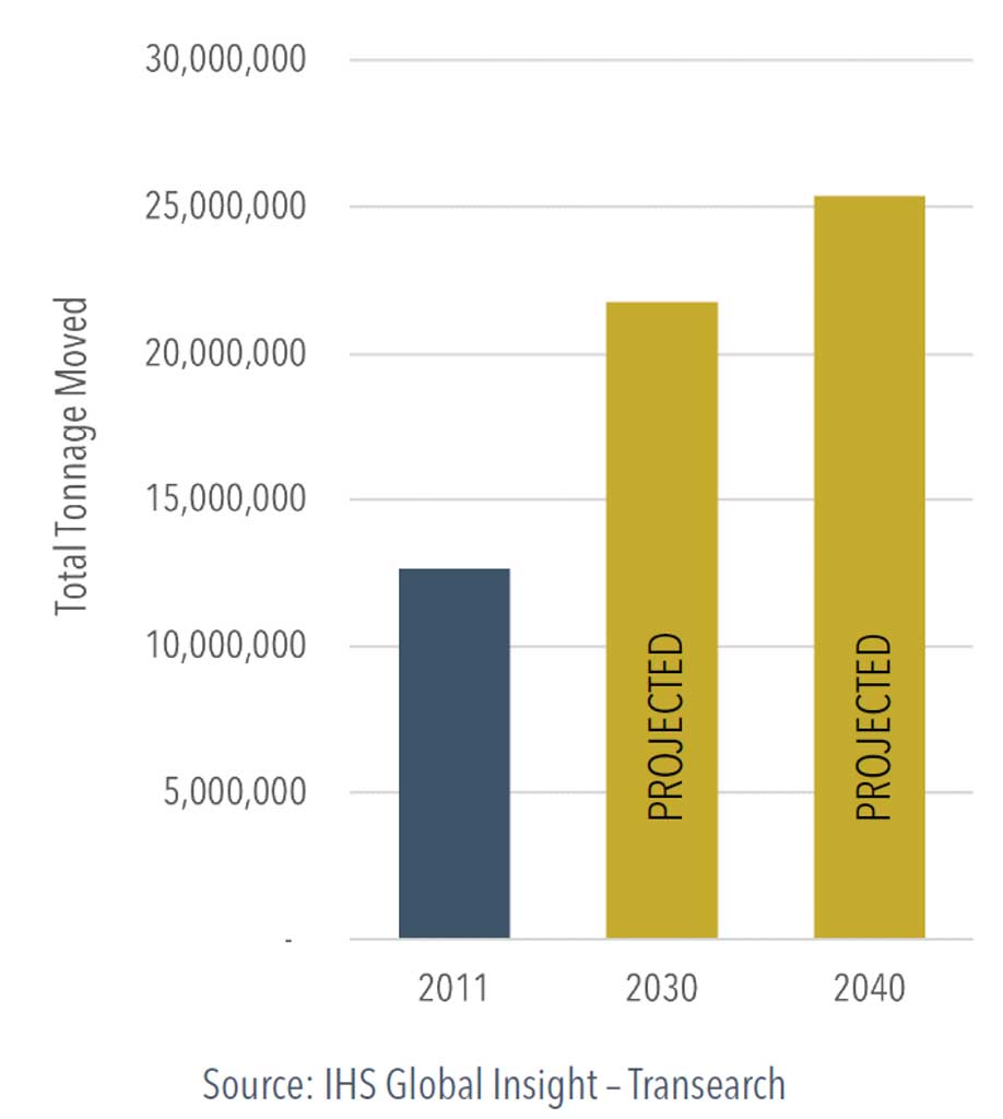
- According to the latest projections by IHS Global Insight (2011), Franklin County’s rail freight network is expected to move 3.25 million tons of freight in 2040 (Figure 38).
- For the decade ending 2021, Franklin County recorded six vehicular crashes involving trains. There were no fatalities over that same period.
Planning Implications
- Rail freight transportation is essential to economic competitiveness and sustained economic growth. Railroads offer connections to national and global markets and have the added benefit of removing trucks from the roadway network, thus preserving pavement conditions and roadway capacity. Preserving and restoring railroad infrastructure is critical given its vital role in Franklin County’s economy.
- The presence of the intermodal facilities fuels interest in the development of distribution centers around the respective “gateways” (National Gateway and Crescent Corridor).
- The railroad terminals expand capacity and improve service as intermodal demand continues to grow.
- PennDOT’s Bureau of Rail, Freight, Ports, and Waterways administers two competitive public funding programs for railroad improvements: the Rail Freight Assistance Program (RFAP) and the Rail Transportation Assistance Program (RTAP). PennDOT awarded $31 million in funding statewide for 26 rail freight projects in 2020.
- During the pandemic, both retailers and manufacturers suffered from delays due to disruptions in the global supply chain. This has led to a greater emphasis on supply chains that are more reliable and resilient. It also translates into shippers exploring alternative modes to deliver greater value for their customers. This trend has given rail carriers an advantage over pre-pandemic shipping practices.
- The growth of e-commerce has also benefited rail carriers in that more freight is moving to large warehouses or distribution centers as opposed to smaller truckloads destined for smaller retail outlets. This trend has played to the railroad’s strength. Norfolk Southern is second to BNSF in total intermodal traffic and its share of intermodal cargo is greater than any other Class I.
- Just a few miles north of Chambersburg, Harrisburg continues to grow in importance as a critical rail intermodal hub or drop point for NS, where westbound traffic originating in New York, Philadelphia, and Baltimore converges at the state’s capital and where traffic from western points is dispersed. Harrisburg is part of the NS Premier Corridor, its busiest main line in the East using trackage acquired from its absorption of Conrail in 1999.
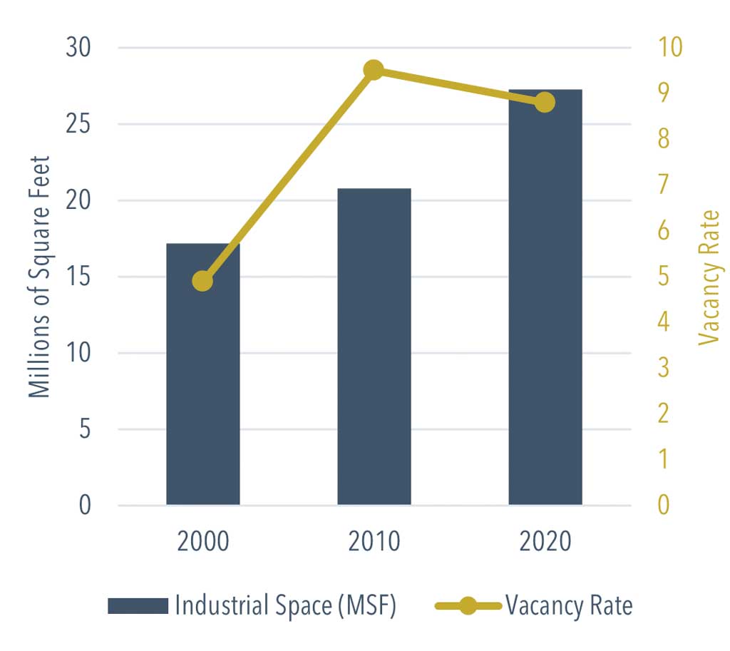
- Data from CoStar indicates that there is 27.3 million square feet (MSF) of industrial space available countywide, with a staggering 5.6 MSF under construction (or more than 20 percent of existing), suggesting that demand for freight transportation will continue to grow.
Goods Movement
Overview and Key Trends
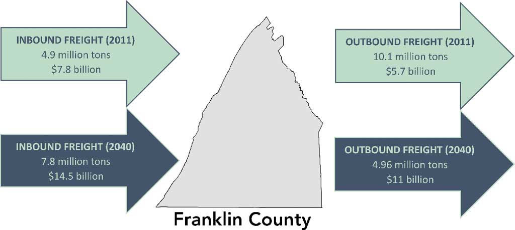
- According to the most recent data available from IHS Global Insight (2011), Franklin County generated more than 15 million tons of freight in 2011. By 2040, freight movement is projected to reach nearly 29 million tons, at $25.5 million in value.
- Nearly 85 percent of freight tonnage moved in and out of the county is transported by truck (Figure 43), with the remainder transported by rail or multiple modes.
- The county’s top exported commodity is broken stone or rip rap, followed by grain. Franklin County’s top import commodity is bituminous coal, with nearly 499,000 tons coming into the county in 2011. Nearly 5 million tons of freight were imported into Franklin County in 2011. By 2040, total imports are expected to exceed 7.7 million tons (Figure 41).
- Franklin County’s top freight-generating companies include Chambersburg Waste Paper (307,600 outbound tons), Volvo Construction Equipment (253,200 outbound tons), and Manitowoc Crane Group (130,800 tons).
- As the LRTP was being developed, construction was underway on an approximately 1.5-million-square-foot WalMart fulfillment center in Antrim Township near the Interstate 81 interchange with US 11. When completed, the facility will create 600 jobs. An additional 1.25 million square feet of warehousing is being proposed in the area.
Planning Implications
- The geographic position of Franklin County and the South Central Pennsylvania region offers close proximity to global economic gateways in New York, Philadelphia, and Baltimore.
- Transportation infrastructure in Franklin County will be expected to accommodate nearly 29 million tons of freight by 2040, nearly doubling the tonnage the system is currently moving. To thoroughly understand freight-related modal movement needs on the network, Franklin County must continue to engage freight and economic development stakeholders.
- Trucking will continue to be the dominant mode of freight movement in the county through the LRTP horizon, impacting the highway and bridge network. Ongoing planning for key freight networks such as the National Highway Freight Network and other critical corridors should continue to be a priority.
- The growth of e-commerce, accelerated by the COVID-19 pandemic, has elevated demand for warehousing and distribution centers—notably along the Interstate 81 corridor. This development pressure could lead to potential impacts on traffic patterns and reliability on Interstate 81 and lower-tier roadway networks. Certain assets may need to be modified to accommodate heavier and wider truckloads. Additional utility infrastructure (e.g., sewer, water, electric) will also be necessary for new facilities to operate.
Active Transportation
Overview and Key Trends
- Franklin County’s active transportation network comprises on-road designated routes (BicyclePA Route S), sidewalks, and trails. Across the state and the nation, active transportation has risen in popularity over the last several years, particularly during the COVID-19 pandemic.
- According to the 2019 American Community Survey five-year estimates, bicycle and pedestrian travel accounts for a 2.3 percent share of journey-to-work trips.
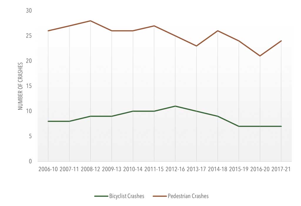
- Over the past decade, crashes involving bicyclists or pedestrians have decreased, averaging 32 crashes annually. This decrease is notable with pedestrian crashes, which dropped from 32 crashes in 2018 to 16 in 2020 (Figure 44).
- Franklin County provides several trails and paths for walking and biking, including the Chambersburg Rail Trail, the Tuscarora Trail, the Appalachian Trail, and the 9/11 National Memorial Trail.
- Concurrent to this plan update, the MPO conducted a suitability analysis of portions of US 11, US 30, and select locally owned routes between the Maryland state line, Chambersburg, and Caledonia State Park for use by cross-state bicyclists. The analysis included an evaluation of a spur from Chambersburg to Shippensburg for a connection with the Cumberland Valley Rail Trail, which would provide a 9.5-mile extension to Newville in Cumberland County.
- The Borough of Chambersburg prepared a Pedestrian and Bicycle Improvements Plan in 2018 intended to educate readers about current infrastructure and active transportation trends. It highlights a series of improvements needed to foster a better-connected active transportation network.
Planning Implications
- Commuter and transit-based bicycle infrastructure is limited throughout Franklin County; however, efforts to expand pedestrian and bicycle networks can be made a priority through incorporation into TIP cycles, land use policy, zoning, and land development ordinances.
- Franklin County’s expansive trail networks can link its communities with major destinations within and beyond county borders. Prioritizing connections to parks, natural areas, and employment and commercial centers will expand opportunities for transportation and recreation.
- The Franklin County MPO will continue to address high traffic speeds, bicycle lanes and facilities, driver and bicyclist education, and roadway and shoulder maintenance to improve safety.
- More comprehensive data is needed for the MPO to effectively plan for the transportation system needs of bicyclists and pedestrians. This data can be acquired through emerging commercial sources or through a bicyclist/ pedestrian counting program.
Aviation
Overview and Key Trends
- The Franklin County Regional Airport is a public-use airport located in Greene Township. It is accessible by US 11 and Interstate 81. Owned and operated by the Susquehanna Area Regional Airport Authority (SARAA), this general aviation airport has 15 based aircraft and one 3,300-foot-long runway.
- As of 2019, the airport employs 29 staff and generates $1.86 million in total economic output. It handles more than 12,000 operations annually, which includes both takeoffs and landings.
- Franklin County Regional Airport supports
the following activities:
- Recreational Flying
- Skydiving Instruction
- Aircraft Maintenance
- Agricultural Spraying
- Aerial Inspections
- Gateway for Visitors
- Law Enforcement and Prisoner Transport
- Medical Transport
- Forest Fire Fighting
- Further connectivity to international destinations is available through Harrisburg International Airport, a 64-mile drive from Chambersburg. Other commercial service passenger connections are available at Hagerstown Regional Airport, located 19 miles south in Washington County, MD.
- Airport Hazard Zoning protects public safety as well as airport viability. The airport hazard area of Franklin County Regional Airport includes zones in four municipalities: Letterkenny Township, Greene Township, Hamilton Township, and Chambersburg Borough. Of these communities, Greene Township is the only municipality that has adopted an Act 164 Airport Hazard Zoning ordinance.
Planning Implications
- The compatibility of airport land uses is important to both local government and the airport. Ensuring this compatibility through Airport Hazard Zoning requires strategic land use management approaches that protect the airport’s viability. Franklin County can assist municipalities within the airport hazard area in enacting this important tool.
Performance Measures
Overview and Key Trends
- The Moving Ahead for Progress in the 21st Century Act (MAP-21) and the Fixing America’s Surface Transportation (FAST) Act promoted achieving measurable outcomes to ensure the effective use of federal transportation funds. The nation’s newest surface transportation legislation, the Infrastructure Investment and Jobs Act (IIJA), also known as the Bipartisan Infrastructure Law (BIL), was passed in November 2021 and maintains this emphasis.
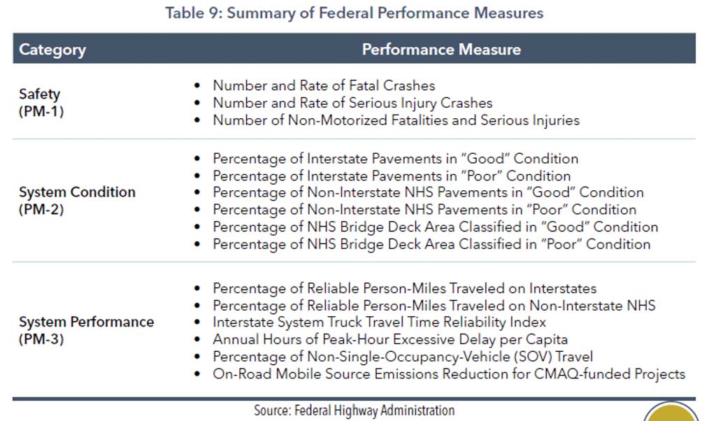
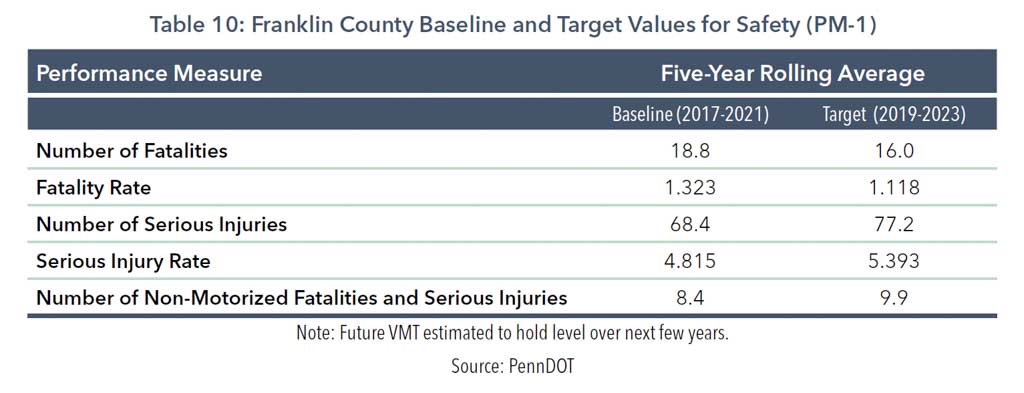
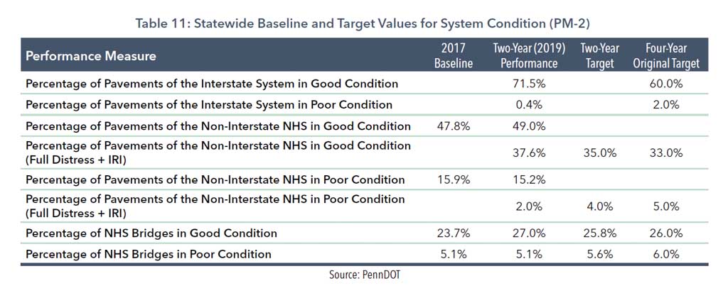
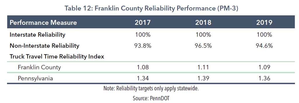
- Performance measures have been developed for Safety (PM-1), System Condition (PM-2), and System Performance (PM-3) (Table 9). PennDOT is responsible for developing state-level performance targets for each of these measures. All of the state’s MPOs and RPOs have the option to support the state targets or establish their own. The Franklin County MPO has committed to supporting the state targets for all three measures (Tables 10, 11, and 1212).
- For PM-1, FHWA will annually determine whether PennDOT has met or made significant progress toward meeting the established performance targets. The PM-2 and PM-3 measures include two- and four-year targets that PennDOT reports to FHWA every two years.
Planning Implications
- IIJA upholds the strategic approach established by MAP-21 and the FAST Act, which is intended to help MPOs, state departments of transportation, and other decision-makers make the best investment decisions to optimize results.
- The Franklin County MPO aims to maximize return on investment for its limited transportation funding in a fiscally constrained environment. Performance measurement in long-range planning allows more effective tracking and reporting of the outcomes of the MPO’s $13.9 million average annual investment in the region’s transportation system.
- The MPO will continue to collaborate with both PennDOT and FHWA on performance measurement as PennDOT looks ahead to reporting its safety targets and serious injury data to FHWA by August 2023 for the Calendar Year 2022 target assessment.
Environmental Resources
Overview and Key Trends
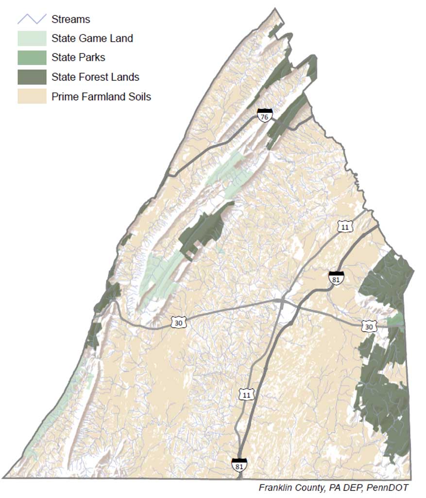
- Franklin County is rich in natural, cultural, and environmental resources, including high-quality streams, trails, prime farmland, forest and park lands, and historical districts (Figure 45). These resources offer recreational, aesthetic, economic, and environmental benefits.
- The MPO performed a high-level evaluation of the environmental resources that could be affected by the LRTP’s projects and identified appropriate mitigation strategies as projects move through the project delivery process.
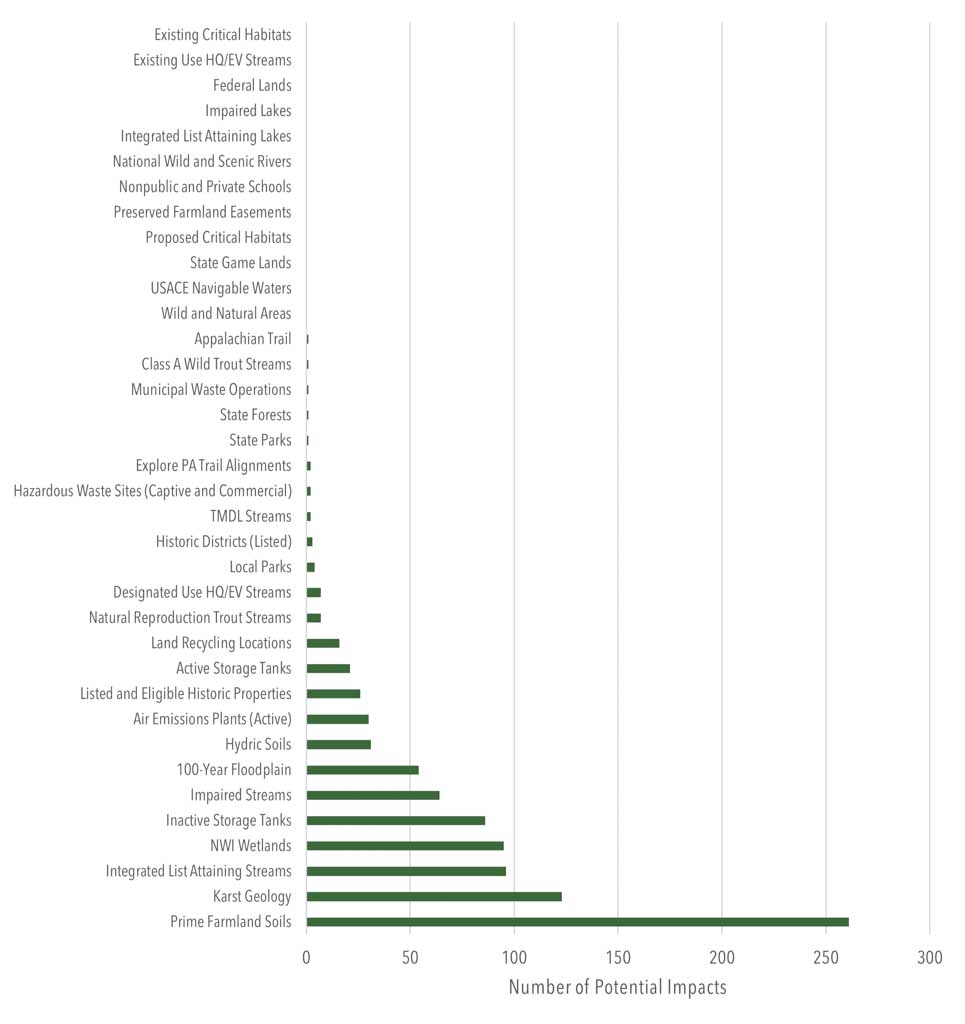
- The evaluation included a buffer analysis, which used the MPO’s 2023 TIP as a sample list of projects. Buffers were applied based on those used in the Pennsylvania National Diversity Inventory (PNDI) environmental review process for transportation projects. Any project that included or implied new roadway construction or a new alignment had a 2,640-foot buffer applied, while all other project types included a 200-foot buffer. Environmental features or resources were considered “potentially impacted” if they intersected with any of these project buffers.
- The buffer analysis determined that features that have high potential for impact by the TIP include “Integrated List Attaining Streams” and prime farmland soils (Figure 46).
- In July 2022, the MPO conducted an outreach meeting with state and local environmental resource agencies where attendees provided insights on conservation concerns as well as potential strategies and data to incorporate into the LRTP. Agencies in attendance included the Pennsylvania Department of Conservation and Natural Resources, Pennsylvania Department of Agriculture, Pennsylvania Historical and Museum Commission, Franklin County Conservation District, PennDOT, and Federal Highway Administration.
Planning Implications
- With prime farmland being abundant throughout the region, the MPO can coordinate with PennDOT, its municipalities, and local farmers to reduce impacts on agricultural land by reducing takings, improving stormwater management, and maintaining access to working fields.
- The MPO will work with all local, regional, state, and federal organizations and agencies to avoid, minimize, or mitigate impacts from projects on the Twelve-Year Program (TYP) through the PennDOT Connects process.
- The MPO will coordinate with PennDOT on monitoring bridges and roadways prone to flooding as well as projects on infrastructure that provides critical connectivity to Plain Sect and other vulnerable populations.
- The MPO will continue to work on projects that close trail gaps. This will help strengthen the county’s trail network and potentially make them eligible for additional funding.
Revenue Forecast
Overview and Key Trends
- Federal planning regulations (23 U.S.C. Section 134) require all MPOs to include a forecast of the revenue they could reasonably expect to receive over the life of the long-range transportation plan to ensure fiscal constraint.
- PennDOT works with FHWA and the state’s MPOs and RPOs in issuing Financial Guidance biennially in sync with the launch of the regional TIP updates. This documentation provides the best estimates available for transportation funding over the longer term and reflects estimated revenues to the state’s Motor License Fund.
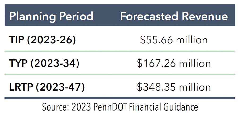
- The IIJA added $14.59 million to Franklin County’s program over the 2023 TIP, boosting its total from $41.06 million to $55.66 million (Table 13). Rising costs related to construction materials, fuel, and the availability of workers are expected to erode the federal windfall.
- Future discretionary dollars from both state and federal sources will also flow into Franklin County but are not accounted for in Table 13 or Figure 47, given their unpredictability.
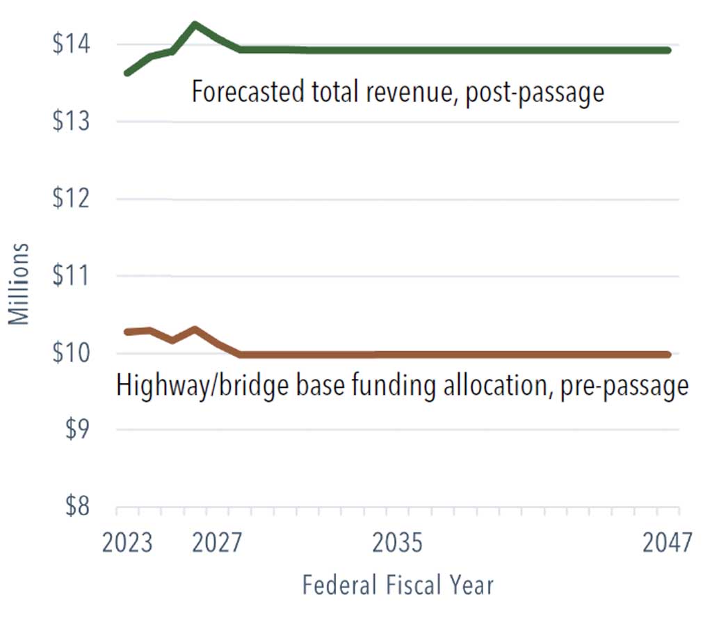
- Pennsylvania’s Interstate Management Program is administered and managed by PennDOT. As with other programs, the cost of the state’s interstate needs continues to outpace available funding. The program is expected to receive approximately $70 million per year through the Bipartisan Infrastructure Law (BIL). This allocation continues overall growth in interstate investment, which is expected to grow to $1 billion by FFY 2028.
- Based on a conservative forecast and sustained IIJA funding levels, the Franklin County MPO is expected to receive nearly $350 million over the next 25 years in today’s dollars. Revenue is expected to average nearly $14 million annually over the life of the LRTP (Figure 47).
Public Engagement
Overview and Key Trends
- As part of the countywide planning process, the MPO administered an online survey between March 28 and May 13, 2022, to collect public feedback on transportation issues and concerns. The MPO promoted the survey’s availability through a press release and social media channels.
- The MPO also provided paper copies of the survey at a variety of locations countywide in an effort to reach a diverse audience. Both the online and paper survey were available. In total, 489 people completed the public survey.
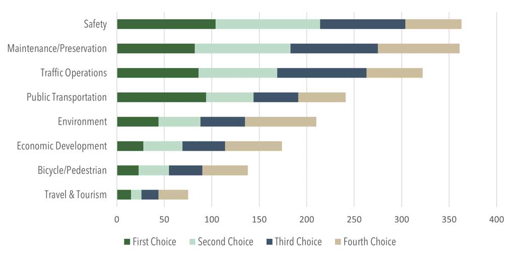
- The survey included three sections, including: identification of top transportation priorities; a rating of potential strategies in support of the priorities; and identification of candidate projects (Figure 49). A total of 1,246 “pins,” or map markers, were placed on an online interactive map. More than 850 of these included corresponding comments. The county released the survey results to the public in August 2022.
- The MPO also administered a 30-day public review and comment period and a public meeting on the draft LRTP, on December 6, 2022.
Survey Results: What are your preferred strategies for each priority area?
Traffic Operations
- Develop plans for addressing congestion.
- Implement new technologies to improve safety and reduce congestion.
- Upgrade and maintain connections to interstates in response to growth in industrial and commercial development within the county and in neighboring counties.
Safety
- Conduct Road Safety Audits on corridors/intersections to identify low-cost, near-term improvements.
- Reduce conflicts between motorized and non-motorized modes.
- Improve predictability of work zones.
Maintenance and Preservation
- Invest in roadway maintenance.
- Invest in bridge maintenance.
- Prioritize improvements on bridges that serve critical freight corridors (US 11, US 30, PA 16).
Environmental
- Address high-volume roadways and bridges prone to flooding.
- Educate municipal governments on best practices for stormwater management.
Bicycle and Pedestrian
- Improve and encourage bicycle and pedestrian accessibility and walkability in downtown areas and large employment hubs.
- Address sidewalk, trail, and bicycle network gaps that impact connectivity.
- Construct separated bicycle/pedestrian facilities and shared-use paths (where feasible).
Public Transportation
- Investigate possibilities for instituting fixed-route bus service.
- Explore the feasibility of additional public transportation options.
- Improve connections with existing public transportation service in neighboring counties.
Economic Development
- Coordinate with PennDOT, developers, and local governments on access management strategies.
- Educate municipal officials and developers on the transportation planning, programming, and project development process.
- Assist local governments in their local land use planning efforts.
Travel and Tourism
- Support connections and access to tourism destinations, including parks, forests, historic/cultural attractions, and trails.
- Improve signage and resources to better direct visitors to tourism destinations.
- Engage the county’s tourism organizations to identify any transportation barriers that could be addressed in future plans and programs.
Planning Implications
- The public’s transportation planning priorities largely mirror that of PennDOT and the MPO, with safety and system maintenance being considered most important. Traffic operations also registered as a high priority with the public—optimizing the performance of operations on existing infrastructure, or relying on strategies other than costly capital projects for addressing safety and congestion.
Introduction
The implementation of the Franklin County Long-Range Transportation Plan will be guided by several overarching principles that provide a framework for plan implementation. The topic areas are listed below and directly mirror the policy ideas that were used to gauge public opinion through the MPO’s surveys:
- Safety
- Traffic Operations
- Bicycle and Pedestrian Accomodation
- Environmental
- Economic Development
- Maintenance and Preservation
- Public Transportation
- Travel and Tourism
The strategies presented within this section are consistent with and build upon policies previously adopted in other county plans. The implementation of the long-range transportation plan will guide the activities of the MPO; its partners at the local, county, state, and federal levels; and the public. Public responses to the MPO’s LRTP survey support the strategic directions of the plan by placing the most emphasis on safety, economic development, and maintenance and development. When prioritizing program spending, the public’s choices reflected the same three policy areas as priorities, but in a slightly different order: fixing the existing infrastructure (system maintenance), traffic management (reliable travel), and safety. Interestingly, the public’s survey responses recognized the difficult choices the MPO faces in providing a balanced program, because no potential implementation strategy received less than three stars out of five. As a result, plan implementation addresses some needs in all the policy areas, while focusing more significant efforts on strategies to affect safety, reliable travel, and system maintenance, consistent with public sentiment. The MPO will continue to work with stakeholders at the local, state, and federal levels and the public to make the plan’s vision a reality.
Strategic Directions
Safety
Introduction
Safety across all transportation modes is the MPO’s highest priority. The annual number of traffic fatalities has averaged 18 in recent years. Total roadway crashes continue to trend upward, even as the demand for travel has remained relatively constant (and even declined during the COVID-19 pandemic). Addressing safety will entail an array of strategies that include education, improved traffic operations, needed countermeasures, and strategic additions to network capacity. The MPO also continues to work with PennDOT to monitor safety performance targets in support of attaining statewide and national highway safety goals.
Conduct road safety audits on corridors/intersections to identify lowcost, near-term improvements.
The Franklin County MPO will also coordinate with PennDOT District 8-0 to identify locations for conducting roadway safety audits as part of its TIP development process. Additionally, the Safe Streets and Roads for All Grant Program (SS4A) funding aims to prevent roadways deaths and serious injuries. The Franklin County MPO will apply for this funding to conduct planning, design, and development activities in support of the Action Plan, in addition to carrying out projects and strategies identified in the plan.
Reduce conflicts between motorized and non-motorized modes (e.g., bicycles, pedestrians, etc.).
The MPO will seek to improve conditions for non-motorized users by working with PennDOT to implement low-cost opportunities to improve non-motorized safety and connectivity. The MPO will ensure that safety measures for non-motorized users are incorporated into programmed projects, when feasible.
Improve predictability of work zones.
Work zones are characterized by traffic pattern changes, the presence of construction workers, and work vehicles frequently entering and leaving construction areas. These factors create increased risk for crashes in work zones. The Franklin County MPO will continue to work with PennDOT to implement best practices to improve the predictability of work zones.
Identify roads used by horse-and-buggy travelers and agricultural traffic (e.g., tractors, farm equipment) for improvement.
Franklin County has a sizeable Plain Sect population and agricultural communities with distinct and unique transportation needs. Truck traffic has increased on county roads that are also heavily frequented by Plain Sect travelers using buggies and bicycles, and walking. The MPO will continue to work with the Plain Sect and agricultural communities to provide wider shoulders and safer intersection crossings on roads identified as priorities.
Explore the feasibility of Traffic Incident Management (TIM) training to improve clearance times, particularly on I-81.
Roadway closures impact emergency response time and the reliability of the county’s roadways. Franklin County will seek to improve the emergency response capabilities of those who are responding to and clearing incidents from the county’s roadways. Other efforts include improving Intelligent Transportation Systems (ITS) infrastructure, including weather information systems and dynamic messaging signs. New data and tools have provided valuable insight into incident management by helping identify the causes of non-recurring congestion. These include crashes, weather, and road construction.
Address safety at at-grade public railroad crossings.
According to FHWA, 94 percent of all rail-related injuries occur at railroad crossings or due to trespassing, and most of them are preventable. Working with federal, state, and local agencies, the MPO will collaborate with PennDOT to address and increase safety at railroad crossings.
Traffic Operations
Introduction
The role of planning for improved traffic operations in transportation planning has increased in recent years in response to several related factors: the increased demand for travel in general, the lack of state and federal funding for major capital-intensive projects, and technological advances. The MPO continues to partner with PennDOT in these areas through such initiatives as the update and maintenance of a Regional Operations Plan (ROP), and planning for Transportation Systems Management and Operations (TSMO).
Fund and develop plans for measuring and addressing congestion.
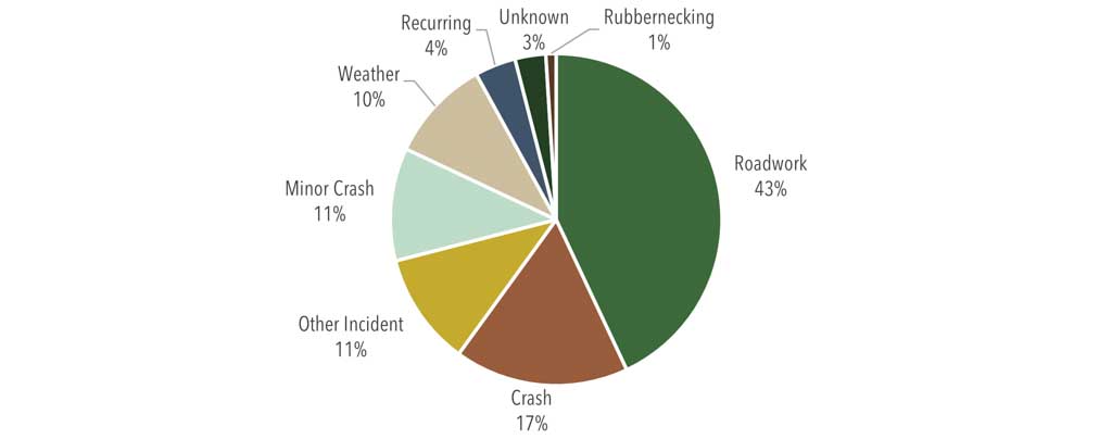
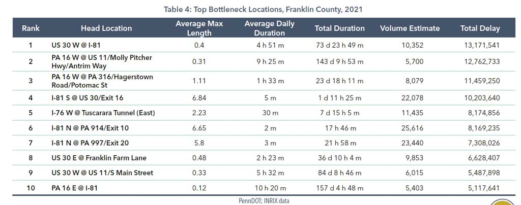
The LRTP planning team used RITIS data to identify the county’s top bottlenecks, based on the extent and duration of congestion. This data provides the MPO with a starting point for addressing the most critical locations where congestion relief is needed. The MPO should further explore PennDOT’s data on estimated causes of congestion after it has been refined and released to better understand how it can be used for making decisions on reducing recurring and non-recurring congestion.
Implement new technologies to improve safety and reduce congestion.
Recommendations from the Eastern Regional Operations Plan (ROP) detailed elsewhere within this plan should be explored.
Upgrade and maintain connections to interstates in response to growth in industrial and commercial development within the county and in neighboring counties.
Interstate 81 accommodates approximately 43 percent of all travel demand within Franklin County, making it the county’s most strategic roadway. It connects the county and its shippers and receivers to the broader state and national economies, with overland access to origins and destinations in other market areas. Planning and programming functions for the interstate are centralized within PennDOT; the MPO must continue its efforts to maintain proper connections and access to the interstate through the TIP process.
Improve Traffic Incident Management and first responder response times.
Incidents on Interstate 81 often have a deleterious effect on the county’s mobility, causing delays on the mainline and congestion and safety concerns on parallel roadways. A Traffic Incident Management Strategy (TIMS) is needed for the length of Interstate 81 in Franklin County. Within these limits there are 10 full-access interchanges and nearly 26 miles of mainline from the Mason-Dixon Line to the Cumberland County border. Franklin County’s neighboring MPO regions in Harrisburg and Lebanon have established TIMS teams to coordinate incident management strategies and enhance response times, including along the I-81 corridor. The Franklin County MPO could coordinate with those MPOs to discuss best practices.
An ideal TIMS program relies on efficient data collection, analysis, and reporting to measure performance and identify gaps that can be addressed. Other options to consider include Computer-Aided Dispatch, electronic crash reporting, traffic management center software, and smart devices that simplify data collection.
Explore cooperative management of traffic signals along priority corridors that cross municipal/county boundaries.
Traffic signals are typically installed by PennDOT and then owned and maintained by the host municipality. Signal equipment that is properly timed and maintained helps improve travel efficiency and reduces the cost of signal operation/ maintenance over time. There are 121 signalized intersections county-wide, and of prime concern are the signals along commercial corridors that traverse multiple municipalities. Prime examples are the signalized corridors of US 11, US 30, and PA 316. New Traffic Signal Technologies grants passed by the General Assembly in July 2022 provide an additional $5 million statewide for municipalities to install and maintain traffic signal technologies such as adaptive signal control, detection, and communication technology.
Identify pre-established detours for use during incidents.
There is a need to compile traffic operations infrastructure assets and planned “colored” detour routes and present it in both spreadsheet and GIS output formats. Moreover, incident management needs (gaps and issues) need to be identified to improve the traffic operations environment.
Bicycle and Pedestrian Accommodation
Introduction
The COVID-19 pandemic was an historic, disruptive event that changed much of the way we live, work, and travel. The health crisis fueled a greater public desire for active transportation and facilities. Interest in bicycle and pedestrian forms of travel as a mode of transportation and form of recreation has increased. Moreover, the MPO seeks to plan for facilities that encourage mode choice and reduce the county’s dependence on the private automobile.
Improve and encourage bicycle and pedestrian accessibility and walkability in downtown areas and large employment hubs.
Bicycle and pedestrian facilities are critical infrastructure for accessibility and mobility. Developing this infrastructure also improves quality of life, connecting people while also improving their health and wellness. The MPO will seek to implement plans that encourage bicycle and pedestrian activity.
Address sidewalk, trail, and bicycle network gaps that impact connectivity.
A key component of improving bicycle and pedestrian safety and increasing micromobility is to connect gaps in sidewalk and trail networks. The MPO should make it a priority to address these concerns with the appropriate stakeholders. A key action item will include the designation of US Bicycle Route 11 through the county, in collaboration with PennDOT, the American Association of State Highway and Transportation Officials (AASHTO), and Adventure Cycling.
Construct separated bicycle/pedestrian facilities and shared-use paths (where feasible).
Greater separation of bicyclists and pedestrians from vehicular traffic can reduce fatalities and serious injuries for all users, while also encouraging greater use of non-motorized modes of transportation. Shared-use paths connect people to jobs, schools, parks, and other transportation routes. In addition to their transportation function, they offer opportunities for improving community health and wellness.
Install pedestrian “countdown” signal heads, particularly in areas that have a high population of seniors and people with disabilities.
Countdown signals help pedestrians judge whether there is sufficient time to cross, which can be especially helpful to mobility-challenged and elderly pedestrians. The MPO will work to identify appropriate crosswalks at which to install these signals.
IIJA/BIL includes a new Vulnerable Roadway Users (VRU) Special Rule. For Pennsylvania, at least 15 percent of the state’s Highway Safety Improvement Program (HSIP) allocation must be spent on VRU-related projects. In Franklin County, the investment will be used to implement a system-wide safety improvement for VRUs by installing pedestrian countdown timers (PCTs). It will require several tiered projects based on the level of effort to install PCTs, which varies for each location. PennDOT District 8-0 took the lead for this effort in 2022.
Improve availability and accessibility of bicycle and pedestrian amenities (e.g., bike racks).
Expanded and improved bicycle and pedestrian infrastructure ensures that a network is in place to make biking and walking viable modes of travel that are safe and convenient. Strategies can support Safe Routes to School, Complete Streets, and Encourage Bicycling and Walking programs.
Develop an Active Transportation committee to help guide bicycle/pedestrian planning efforts.
An Active Transportation Advisory Committee, comprising bicyclists, pedestrians, and other active movers, can advise the MPO based on their own personal experiences and related work backgrounds with the goal of implementing an active transportation plan. Such a committee could help guide bicycle and pedestrian planning efforts at a local level and form a consortium for regional dialog and planning as it relates to active transportation.
Environmental
Introduction
Transportation’s impact on the environment remains a critical policy issue for the MPO. County planning staff will continue to work with all agencies to avoid, minimize, and mitigate impacts from transportation projects on the environment. The MPO’s ongoing involvement in the PennDOT Connects process will further facilitate the identification of potential impacts of projects early in the preliminary design process so that agencies can be contacted to review and comment on strategies to reduce negative impacts.
Coordinate with the Franklin County Conservation District and other environmental resource agencies to incorporate best practices into transportation projects and planning (e.g., runoff control, green spaces, stormwater).
Consideration should be given to incorporating resiliency into the MPO’s project prioritization process. Ongoing coordination with federal, state, and local environmental agencies is critical in prioritizing these vulnerable locations. Franklin County should partner with its municipalities and PennDOT to identify where stormwater infrastructure is lacking or could be improved on roadways with high levels of vulnerability in extreme rain and snow events. This reduces the need for emergency roadwork on critical highways and bridges and the need for emergency funds due to flood damage.
Address high-volume roadways and bridges prone to flooding.
The MPO continues to work toward improving the resiliency of its transportation network in the face of both natural and man-made disruptions. Part of this effort includes identifying high-volume roadways that are prone to flooding, which affects network reliability.
Educate municipal governments on best practices for stormwater management.
The MPO will work with municipalities to help advance MS4 or municipal separate storm sewer systems, countywide. These systems help protect water quality and manage runoff and flooding during storms. Helping to develop these programs throughout the county can help protect transportation infrastructure during severe weather events.
Plan for use of alternative fuels (e.g., electric-vehicle charging stations, etc.).
Many states (including Pennsylvania) are currently in the process of developing National Electric Vehicle Infrastructure (NEVI) plans for developing essential charging corridors to help spur electric vehicle adoption. While PennDOT implements its NEVI plan for implementing electric-vehicle infrastructure, the MPO can prepare and identify which corridors will become electrified and prepare for this new infrastructure.
Economic Development
Introduction
The MPO recognizes transportation’s role in not only providing mobility and access, but also in maintaining and improving the county’s economic competitiveness. In fact, this is one of the federal planning factors for transportation and one of the guiding principles in the county’s planning and programming activity. The LRTP recognizes transportation’s impact in connecting workers to jobs, consumers to commercial outlets, and the county’s businesses and industries in general to consumer market areas both near and far. Within Franklin County, transportation is a major employment sector in its own right, constituting 11.6 percent of the county’s total employment—more than double the state rate of 4.8 percent.
Coordinate with PennDOT, developers, and local governments on access management strategies.
A safe and efficient transportation system is a key component of an area’s quality of life. It has direct bearing on mobility and the access of people and goods to employment, shopping, and recreation. Access management strategies help improve the safety and efficiency of traffic by reducing congestion and decreasing accidents while also preserving community character through site design and land use planning.
Educate municipal officials and developers on the transportation planning, programming, and project development process.
In conjunction with the PennDOT District 8-0 office, the MPO can hold regular outreach and information sessions with municipal governments and developers countywide to keep them up to date on transportation developments and inform them of the procedures that are required as part of the transportation planning process.
Assist local governments in their local land use planning efforts.
The Franklin County MPO should be involved in any comprehensive planning efforts spearheaded by municipal governments to help advise on local land use planning and the strategic placement and development of economic centers and design as it relates to transportation infrastructure.
Give funding priority to critical freight corridors (e.g., PA 16, US 30, US 11).
Franklin County’s share of FHWA’s priority freight designations includes portions of US 11 in Antrim Township (between Greencastle and I-81), PA 16 in Antrim Township (between I-81 and the Village of Shady Grove), and portions of PA 997, US 11, and PA 433 between I-81 and Letterkenny Army Depot. Even as these segments have been certified by FHWA and are eligible for National Highway Freight Program (NHFP) funding, the MPO may also consider elevating these and other priority freight segments for suballocating available TIP funding for these corridors.
Encourage development that supports multiple transportation options, such as walking, biking, and regional/community ridesharing.
Increased access to low-cost multimodal transportation options expands economic opportunity by giving non-drivers access to jobs, businesses, and other locations that are otherwise out of reach without a car. Multimodal transportation options also expand the labor force available to some businesses.
Develop a countywide freight plan.
The passage of MAP-21 and its successor legislation, the FAST Act, placed a greater emphasis on planning for goods movement. MPOs and DOTs alike have put forth plans and initiatives to address the growth of freight and its impact on public infrastructure. Surrounding MPO regions in Harrisburg and Hagerstown have already developed and adopted regional freight plans. The availability of additional federal funding through formula and new discretionary programs from IIJA/ BIL, coupled with the explosive growth of warehousing and distribution centers in Franklin County, make this a critical action item for the future.
Maintenance and Preservation
Introduction
With more than 1,700 linear miles of roadway and approximately 320 state-owned bridges (and more than 100 locally owned bridges), Franklin County has an extensive and mature transportation system. While there are a few major capacity-adding projects planned (a new Exit 12 on Interstate 81 being a prime example), the MPO will use new tools and techniques to invest in system maintenance and preservation. New approaches such as Lowest LifeCycle Cost will provide needed attention to the system to extend the life of its transportation assets and provide the MPO with the greatest benefit for its limited transportation funding.
Invest in roadway maintenance.
The MPO will continue to work with PennDOT District 8-0 to fund and plan for resurfacing and pavement preservation activities. A regular investment in maintaining roadway pavements will reduce the need for large investments in roadway reconstruction projects. It will also reduce the need for road closures and lengthy detours. PennDOT’s forthcoming asset management planning tool will include the county’s unconstrained needs by each highway category on PennDOT’s Business Plan Networks.
Invest in bridge maintenance.
The Franklin County MPO will continue to work with PennDOT District 8-0 to fund and plan for routine bridge maintenance activities. A regular investment in maintenance will reduce the need for large, one-time investments in necessary rehabilitation or replacement projects. The goal is to extend the useful life of an asset and prevent costly emergency repair situations. A source of sustainable funding for bridge maintenance should be identified and programmed on future TIPs. PennDOT is developing a Web-based asset management planning tool that will be accessible by the MPO. It will include the county’s unconstrained needs by each highway category on PennDOT’s Business Plan Networks, consistent with asset management principles in the Pennsylvania Transportation Asset Management Plan (TAMP).
Collaborate with municipalities to improve local bridge conditions.
Local bridges are often ineligible for federal transportation funds, with the exception of the Off-System Bridge program. It establishes criteria for funding improvements to bridges that are not on the Federal-Aid System. PennDOT is required to apply 15 percent of its annual funding allocation to these bridges. The Franklin County MPO will assist its municipal partners in addressing local bridge needs by maintaining a list of priority off-system bridges to refer to when federal funding is available. The MPO in August 2022 moved to waive the 5 percent local match for federal dollars for off-system bridges. This will give the MPO more flexibility with its TIP, and will assist municipalities that are still recovering from the impact of the COVID-19 pandemic.
Public Transportation
Introduction
The MPO remains committed to planning for public transportation services for its residents. This included the adoption of a Local Coordinated Plan in July 2021, and the launch of a pilot program for microtransit (rabbittransit’s “Stop Hopper” program) in August 2022. Public transportation is crucial to the county’s transportation system, as it provides accessible and affordable transportation for people with limited mobility options. Planning for this mode should assess transportation needs for seniors, persons with disabilities, and low-income individuals; strategies and/or projects to address any gaps between current services and future needs; and priorities for implementation based on resources, time, and feasibility.
Investigate emerging and traditional transit options to make connections between residential areas and major commercial and employment centers.
Fixed-route bus service is an important element of the regional economy, providing people with mobility and access to employment, community resources, medical care, and recreational opportunities. The Franklin County MPO and regional partners will investigate possibilities for instituting fixed-route service.
Explore the feasibility of additional public transportation options (e.g., microtransit services, vanpools, employer sponsored shuttles).
The implementation of the new microtransit service (“Stop Hopper”) serves as a two- to three-year pilot for the Greater Chambersburg area. The MPO will monitor the pilot’s effectiveness and coordinate with rabbittransit, PennDOT, and the Franklin County Commissioners on its evolution.
Improve connections with existing public transit service in adjacent counties.
PennDOT and Franklin County MPO have worked together for many years to improve transportation infrastructure in the region. Moving forward, the MPO will continue to work with PennDOT to improve connections with adjacent transit agencies (e.g., Capital Area Transit) to create a region with more connected commercial and recreation hubs.
Support ridesharing (e.g., carpool, vanpool) programs that connect people to jobs and essential services.
Analysis of travel patterns in the county indicates several places that could serve as parking lots for ridesharing programs. The county should work with municipalities where appropriate to implement park-and-ride lots through the land development process and through partnerships with rabbittransit and Commuter Services.
Update the Local Coordinated Plan.
Since 2007, Coordinated Plans have been a crucial tool for regional multimodal transit planning. Coordinated Plan requirements place a large emphasis on stakeholder engagement and public involvement to ensure that the plan is designed by, and benefits, those who need and use public transportation. The MPO acknowledges the need to improve mobility throughout the county, including the interconnectedness of the county and the inter- and intra-county travel of residents. While the current plan serves as an administrative update of its predecessor, the next update should engage the public and transit stakeholders.
“When individuals have increased mobility options, they have increased possibilities to improve their quality of life. We’re proud to offer the Stop Hopper as an affordable way to help riders in smaller, rural communities access the benefits of public transit.”
– Rich Farr, Executive Director, SRTA
Travel and Tourism
Introduction
The passage of the FAST Act in 2015 added new provisions for long-range transportation planning, including the enhancement of travel and tourism. The MPO recognizes the role that travel and tourism have on the transportation system, and the need for the system to be intuitive and easy to navigate for the county’s visitors, as well as serving the county’s many tourist destinations. Tourism continues to be a major industry, and especially so as the Baby Boomer generation transitions out of the workforce with more disposable income and a greater degree of mobility compared to previous generations.
Support connections and access to tourism destinations, including parks, forests, historic/cultural attractions, and trails.
Not only do trails, parks, and cultural attractions provide an opportunity for outdoor recreation, they can also provide a means of transportation or a commuting connection. By promoting the PA Department of Conservation and Natural Resources’ (DCNR’s) grant programs, the MPO can assist the county and local municipalities in securing funding for trail gap closures and enhancing local tourism and travel destinations.
Improve signage and resources to better direct visitors to tourism destinations, parks/forests/trails, etc.
In improving access and connectivity to tourism destinations and visitor centers, efforts can be made to improve the signage and resources at these facilities countywide.
Collect relevant transportation data related to tourism and use in transportation planning efforts.
Data related to tourism should be part of the planning and programming process to ensure that future projects and programs are supportive of the county’s tourism industry. Ensuring the proactive involvement of tourism groups—such as the Franklin County Visitors Bureau—in the county’s transportation planning process will help ensure tourism interests are being considered.
Appendix A: Investment Plan (2023–2047)
Transportation Improvement Program (2023–2026)
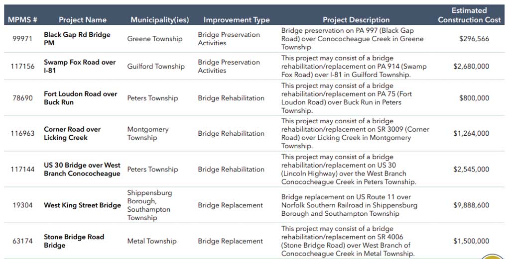
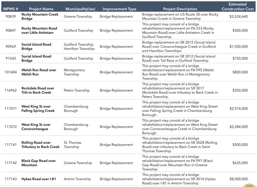
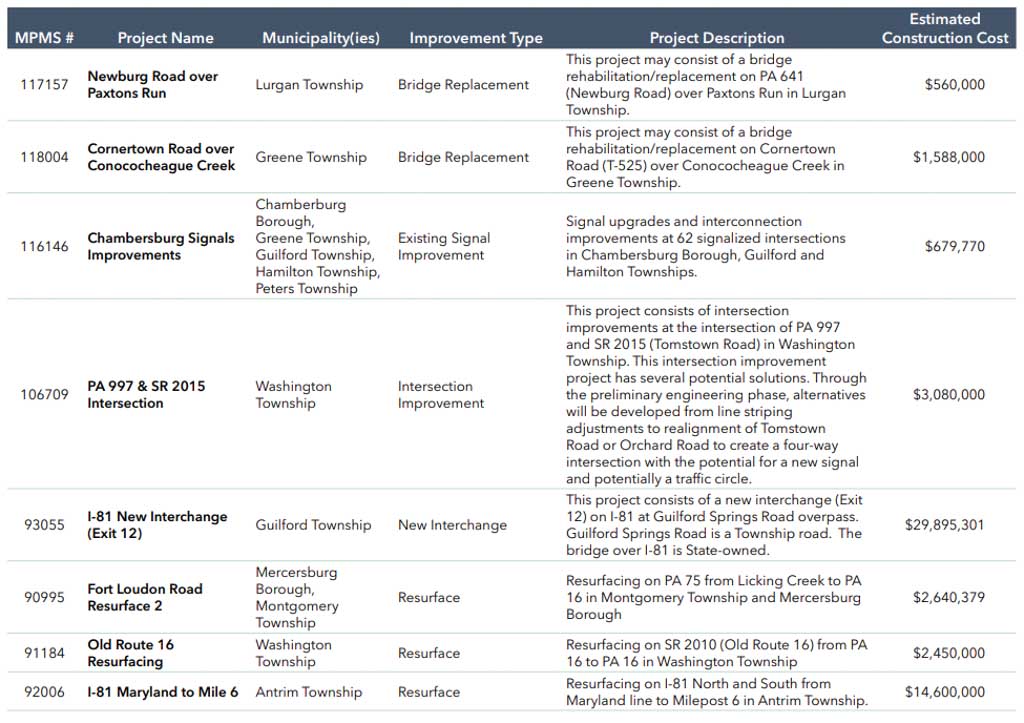
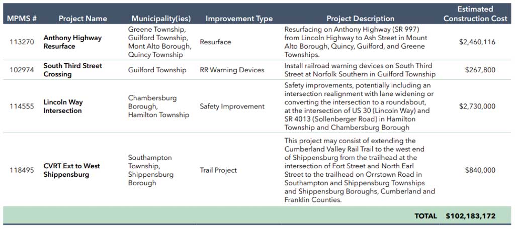
Balance of the Twelve-Year Program (2027–2034)
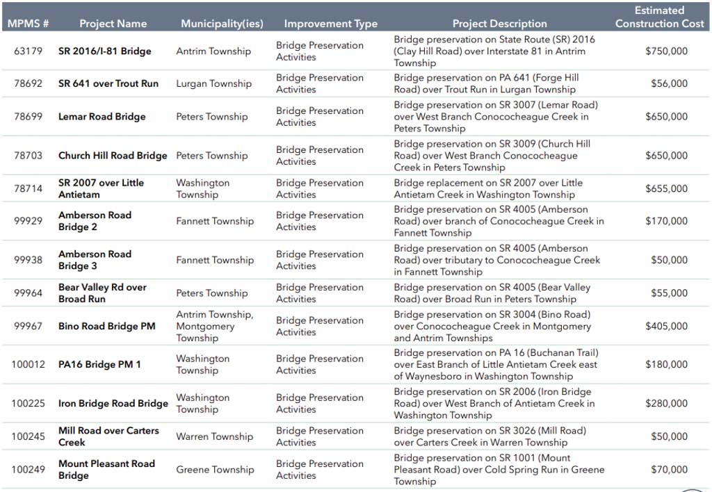
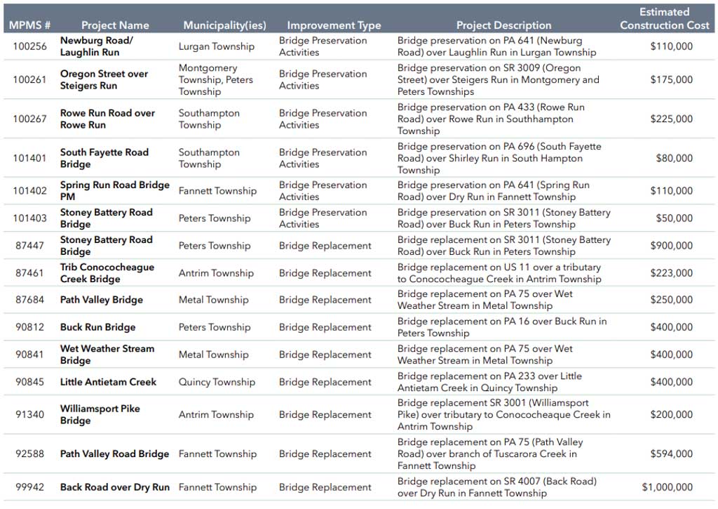
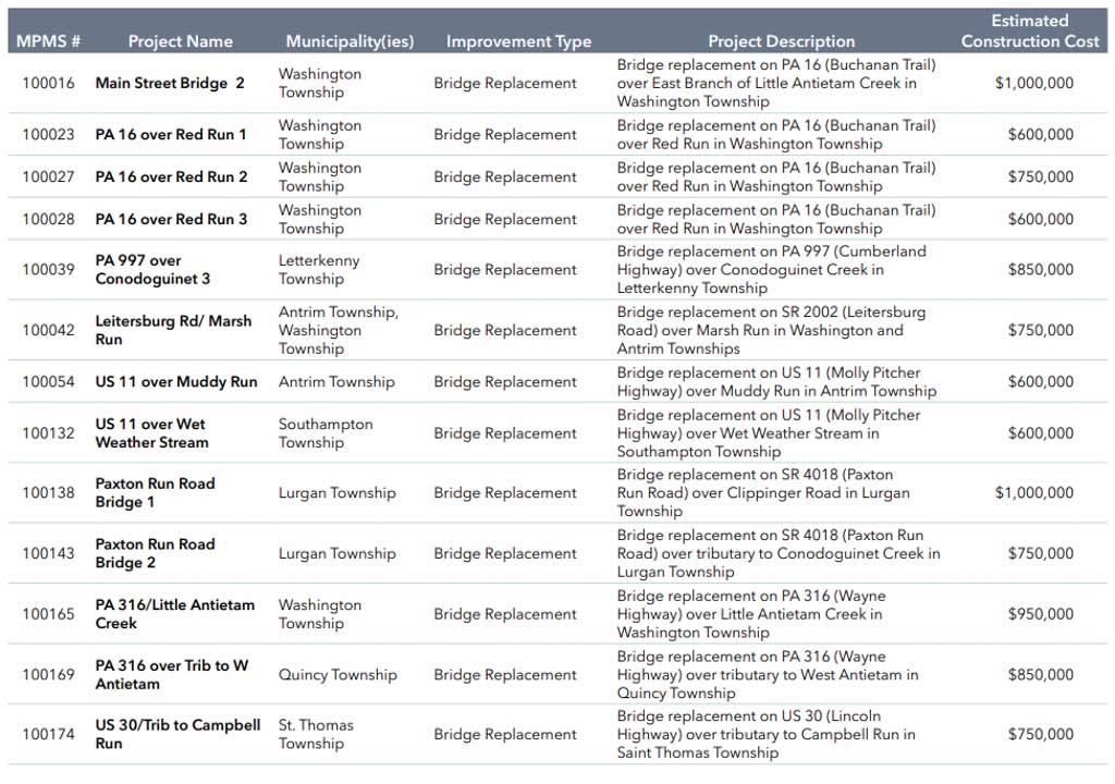
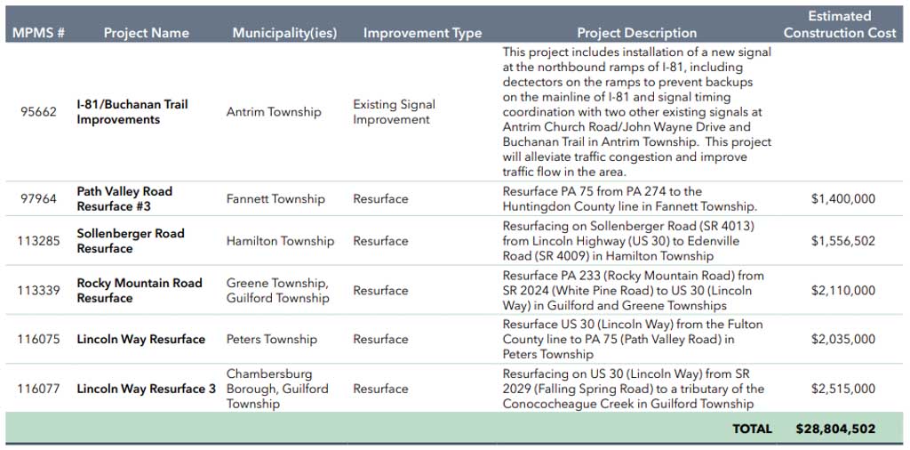
Countywide Line Items, Out Years (2035–2047)
In lieu of specific projects, line-item amounts were determined for the plan’s “out years” (2035-2047) in consultation with PennDOT District 8-0 and Central Office. The MPO used PennDOT’s 2023 Financial Guidance documentation for the 2023 program to determine the shares of funding to go toward three project types: Highway, Bridge, and Safety.
The MPO determined shares based on funding available for specific funding programs, i.e., “Highway” amounts based on funding allocations from NHPP, STP, and State Highway; “Bridge” amounts based on State Bridge and Off-System Bridges; and “Safety” from HSIP. The shares resulted in a 66/23/11 split, respectively, as shown in the following table.
Appendix A Countywide Line Items Table
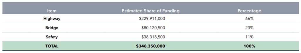
Appendix B: Illustrative Projects
Note that the following projects are unfunded, and illustrative only. The MPO will consider the candidates from this project listing as future programs are being developed.
Illustrative Projects Tables
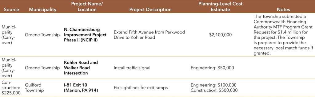
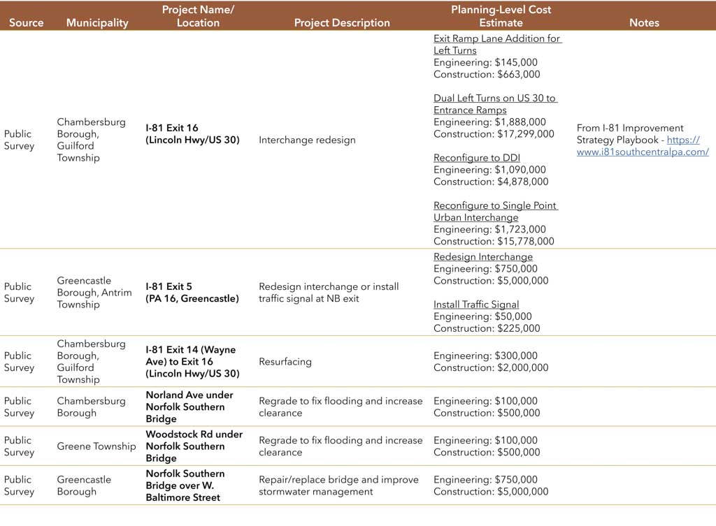
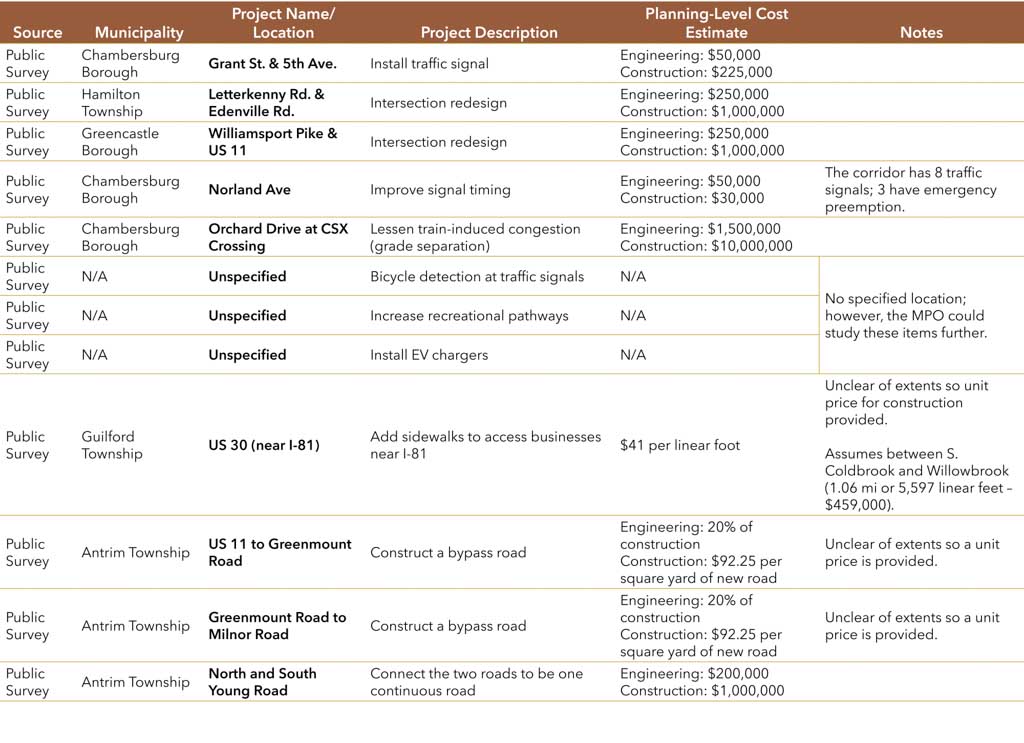
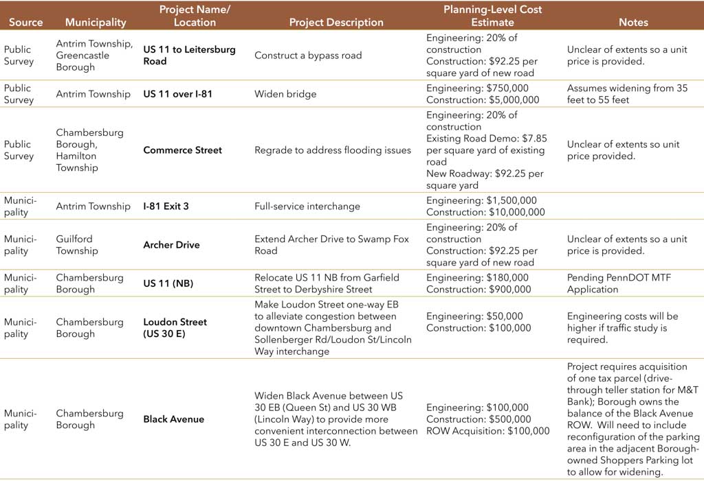
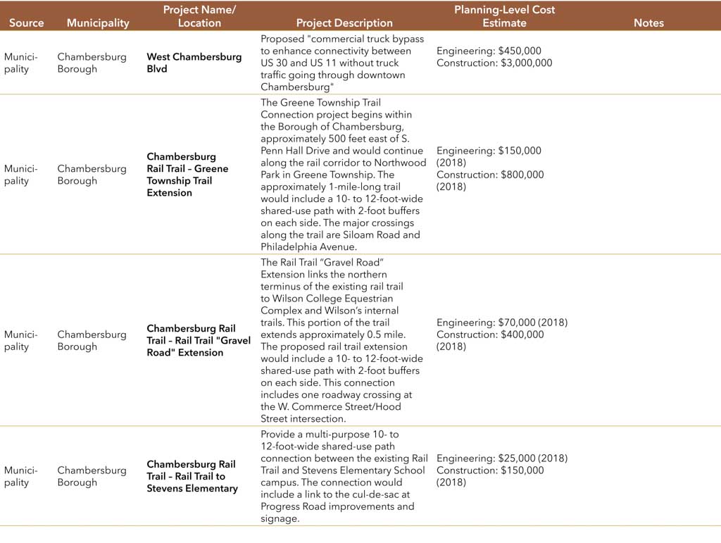
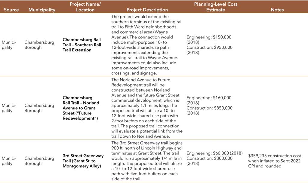
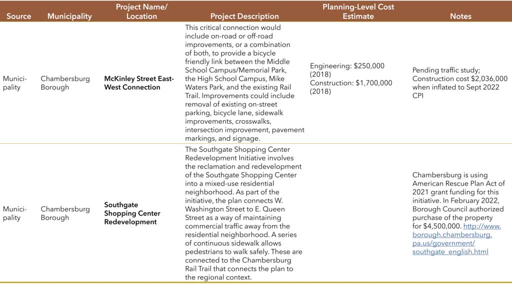
Appendix C: Air Quality Determination
Transportation Conformity Determination Report - Franklin County
Executive Summary
As part of its transportation planning process, the Franklin County Metropolitan Planning Organization (FCMPO) completed the transportation conformity process for the updated 2045Long Range Transportation Plan (LRTP) and the FY 2023-2026 Transportation Improvement Program (TIP).This report documents that theTIP and LRTP meets the federal transportation conformity requirements in 40 CFR Part 93. Note the TIP has not changed from previous conformitydeterminations.
Clean Air Act (CAA) section 176(c) (42 U.S.C. 7506(c)) requires that federally funded or approved highway and transit activities are consistent with (“conform to”) the purpose of the State Implementation Plan (SIP). Conformity to the purpose of the SIP means that transportation activities will not cause or contribute to new air quality violations, worsen existing violations, or delay timely attainment of the relevant NAAQS or any interim milestones. EPA’s transportation conformity rules establish the criteria and procedures for determining whether metropolitan transportation plans, TIPs, and federally supported highway and transit projects conform to the SIP.
On February 16, 2018, the United States Court of Appeals for the District of Columbia Circuit in South Coast Air Quality Mgmt. District v. EPA(“South Coast II,” 882 F.3d 1138) held that transportation conformity determinations must be made in areas that were either nonattainment or maintenance for the 1997 ozone national ambient air quality standard (NAAQS) and attainment for the 2008 ozone NAAQS when the 1997 ozone NAAQS was revoked. These conformity determinations are required in these areas after February 16, 2019.Franklin Countywas maintenance at the time of the 1997 ozone NAAQS revocation on April 6, 2015 and was also designated attainment for the 2008 ozone NAAQS on May 21, 2012. Therefore, per the South Coast II decision, this conformity determination is being made for the 1997 ozone NAAQS.
This conformity determination was completed consistent with CAA requirements, existing associated regulations at 40 CFR Parts 51.390 and 93, and the South Coast II decision, according to EPA’s Transportation Conformity Guidance for the South Coast II CourtDecisionissued on November 29, 2018.
1.0 Background
1.1 Transportation Conformity Process
The concept of transportation conformity was introduced in the CAA of 1977, which included a provision to ensure that transportation investments conform to a State Implementation Plan (SIP) for meeting the Federal air quality standards. Conformity requirements were made substantially more rigorous in the CAA Amendments of 1990. The transportation conformity regulations that detail implementation of the CAA requirements were first issued in November 1993, and have been amended several times. The regulations establish the criteria and procedures for transportation agencies to demonstrate that air pollutant emissions from metropolitan transportation plans, transportation improvement programs and projects are consistent with (“conform to”) the State’s air quality goals in the SIP. This document has been prepared for State and local officials who are involved in decision making on transportation investments.
Transportation conformity is required under CAA Section 176(c) to ensure that Federally-supported transportation activities are consistent with (“conform to”) the purpose of a State’s SIP. Transportation conformity establishes the framework for improving air quality to protect public health and the environment. Conformity to the purpose of the SIP means Federal Highway Administration (FHWA) and Federal Transit Administration (FTA) funding and approvals are given to highway and transit activities that will not cause new air quality violations, worsen existing air quality violations, or delay timely attainment ofthe relevant air quality standard, or any interim milestone.
1.2 National Ambient Air Quality Standards
The CAA requires the EPA to set NAAQS for pollutants considered harmful to public health and the environment. A nonattainment area is any area that does not meet the primary or secondary NAAQS. Once a nonattainment area meets the standards and additionalredesignation requirements in the CAA [Section 107(d)(3)(E)], EPA will designate the area as a maintenance area.
Franklin Countyis currently designated as a maintenance area under the 1997 8-hour ozone NAAQS. The countyis in attainment of the 2008 and 2015 8-hour ozone, 2006 24-hour PM2.5 and 2012 annual PM2.5 NAAQS. Transportation conformity requires nonattainment and maintenance areas to demonstrate that all future transportation projects will not prevent an area from reaching its air quality attainment goals.
1997 8-hour Ozone NAAQS
The EPA published the 1997 8-hour ozone NAAQS on July 18, 1997 (62 FR 38856), with an effective date of September 16, 1997. An area was in nonattainment of the 1997 8-hour ozone NAAQS if the 3-year average of the individual fourth highest air quality monitor readings, averaged over 8 hours throughout the day, exceeded the NAAQS of 0.08 parts per million (ppm). On May 21, 2013, the EPA published a rule revoking the 1997 8-hour ozone NAAQS, for the purposes of transportation conformity, effective one year after the effective date of the 2008 8-hour ozone NAAQS area designations (77 FR 30160).
On February 16, 2018 the D.C. Circuit reached a decision in South Coast Air Quality Management District v. EPA, Case No. 15-1115. In that decision, the court vacated major portions of the final rule that established procedures for transitioning from the 1997 ozone NAAQS to the stricter 2008 ozone NAAQS. By court decision, Franklin Countywas designated asan “orphan” maintenance area since the area was maintenance for the 1997 ozone NAAQS at the time of its revocation (80 FR 12264, March 6, 2015) and was designated attainment for the 2008 NAAQS in EPA’s original designations for this NAAQS (77 FR 30160, May 21, 2012).
2008 and2015 8-hour Ozone NAAQS
The EPA published the 2008 8-hour ozone NAAQS on March 27, 2008 (73 FR 16436), with an effective date of May 27, 2008. EPA revised the ozone NAAQS by strengthening the standard to 0.075 ppm. Thus, an area is in nonattainment of the 2008 8-hour ozone NAAQS if the 3-year average of the individual fourth highest air quality monitor readings, averaged over 8 hours throughout the day, exceeds the NAAQS of 0.075 ppm. FranklinCounty was designated as an attainment area under the 2008 8-hour ozone NAAQS, effective July 20, 2012 (77 FR 30088).
In October 2015, based on its review of the air quality criteria for ozone and related photochemical oxidants, the EPA revised the primary and secondary NAAQS for ozone to provide requisite protection of public health and welfare, respectively (80 FR 65292). The EPA revised the levels of both standards to 0.070 ppm, and retained their indicators, forms (fourth-highest daily maximum, averaged across three consecutive years) and averaging times (eight hours). Under the Clean Air Act, the EPA administrator is required to make all attainment designations within two years after a final rule revising the NAAQS is published. Franklin County is in attainment of the 2015 8-hour ozone NAAQS.
2.0 FCMPO LRTP and TIP
The Long-Range Transportation Plan (LRTP) serves as the official transportationplan for a metropolitan area.TheLRTP documents the current and future transportation demand and identifies long-term improvements and projects to meet those needs. TheLRTP was recently updated by the FCMPOto guide decision-making about transportationimprovements in the county. The planning factors specified in federal regulations provide the framework for developing theLRTP. In addition,PennDOT provides guidance to help MPOs prepare LRTPs, and local policies and plans play a role in LRTP development to ensure transportation investments address current and future needs.The Franklin County LRTP includes projects from the Pennsylvania Department of Transportation (PennDOT) Twelve Year Program (TYP).
In addition, MPOs and Rural Planning Organizations (RPOs) each develop a TIP at the local level, which reflects the first four years of the PennDOT TYP.The Statewide Transportation Improvement Program (STIP) covers the entire state and includes the individual TIPs representing each Planning Partner. Federal Law requires TIPs to be updated at least every four years. Pennsylvania’s MPOs and RPOs update their TIPs every two years during the TYP update process.
The February 16, 2018, South Coast vs. EPA Court decision did not vacate EPA’s revocation of the 1997 ozone standard and the decision does not change the area’s attainment status. Therefore, while such areas might be required to meet conformity requirements as part of anti-backsliding controls, such areas are not considered nonattainment or maintenance areas under the Transportation Planning Rule (23 CFR 450.104). Such areas continue to complete 5-year plan update cycles as described in 23 CFR 450.324(c). The 5-year metropolitan transportation plan update cycle continues to apply from the date of the most recent MPO metropolitan transportation plan adoption (not the most recent FHWA/FTA conformity determination). While these areas have a 5-year plan cycle for transportation planning purposes, as a result of the court decision they must still meet the 4-year frequency requirements for conformity determinations on TIPs and LRTPsas required by 40 CFR 93.104.
Appendix A provides a listing of the regional significant projects that are funded in the TIP and LRTP within FranklinCounty. Regionally significant projects include transportation projects (other than exempt projects as defined under 40 CFR 93.126- 127) that areon a facility which serves regional transportation needs.
3.0 Transportation Conformity Process
Per the court’s decision in South Coast II, beginning February 16, 2019, a transportation conformity determination for the 1997 ozone NAAQS will be needed in 1997 ozoneNAAQS nonattainment and maintenance areas identified by EPA for certain transportation activities, including updated or amended TIPs and LRTPs. Once US DOT makes its 1997 ozone NAAQS conformity determination, conformity will be required no less frequently than every four years. This conformity determination report addresses transportation conformity for the FCMPO 2023-2026 TIP and 2045LRTP.
4.0 Transportation Conformity Requirements
4.1 Overview
On November 29, 2018, EPA issued Transportation Conformity Guidance for the South Coast II Court Decision (EPA-420-B-18-050, November 2018) that addresses how transportation conformity determinations can be made in areas that were nonattainment or maintenance for the 1997 ozone NAAQS when the 1997 ozone NAAQS was revoked, but were designated attainment for the 2008 ozone NAAQSin EPA’s original designations for this NAAQS (May 21, 2012).
The transportation conformity regulation at 40 CFR 93.109 sets forth the criteria and procedures for determining conformity. The conformity criteria forTIPs and LRTPs include: latest planning assumptions (93.110), latest emissions model (93.111), consultation (93.112), transportation control measures (93.113(b) and (c), and emissions budget and/or interim emissions (93.118 and/or 93.119). For the 1997 ozone NAAQS areas, transportation conformity for TIPs and LRTPs for the 1997 ozone NAAQS can be demonstrated without a regional emissions analysis, per 40 CFR 93.109(c). This provision states that the regional emissions analysis requirement applies one year after the effective date of EPA’s nonattainment designation for a NAAQS and until the effective date of revocation of such NAAQS for an area. The 1997 ozone NAAQS revocation was effective on April 6, 2015, and the South Coast II court upheld the revocation. As no regional emission analysis is required for this conformity determination, there is no requirement to use the latest emissions model, or budget or interim emissions tests.
Therefore, transportation conformityfor the 1997 ozone NAAQS can be demonstrated by showing the remaining requirements in Table 1 in 40 CFR 93.109 have been met. These requirements, whichare laid out in Section 2.4 of EPA’s guidance and addressed below, include:
- Latest planning assumptions (93.110)
- Consultation (93.112)
- Transportation Control Measures (93.113)
- Fiscal constraint (93.108)
4.2 Latest Planning Assumptions
The use of latest planning assumptions in 40 CFR 93.110 of the conformity rule generally applies to a regional emissions analysis. In the 1997 ozone NAAQS areas, the use of latest planning assumptions requirement applies to assumptions about transportation control measures (TCMs) in an approved SIP. However, the Franklin County SIP maintenance plan does not include any TCMs.
4.3 Consultation Requirements
The consultation requirements in 40 CFR 93.112 were addressed both for interagency consultation and public consultation.
As required by the federal transportation conformity rule, the conformity process includes a significant level of cooperative interaction among federal, state, and local agencies. For this air quality conformity analysis, interagency consultation was conducted as required by the Pennsylvania Conformity SIP. This included conference call(s) or meeting(s) of the Pennsylvania Transportation-Air Quality Work Group (including the Pennsylvania Department of Transportation (PennDOT), DEP, EPA, FHWA, FTA and representatives from larger MPOs within the state).
Meeting and conference calls were conducted quarterly in 2022 to review all planning assumptions and to discuss the template and content for transportation conformity analyses in 1997 ozone orphan areas.
TheTIP, LRTP and associated conformity determination hasundergone the public participation requirements as well as the comment and response requirements according to the procedures established in compliance with 23 CFR part 450, FCMPO’s Public Participation Plan, and Pennsylvania's Conformity SIP. The draft document was made available for a 30-day public review and comment period, which included a public meeting.
4.4 Fiscal Constraint
The planning regulations, Sections 450.324(f)(11) and 450.326(j), require the transportation plan to be financially constrained while the existing transportation system is being adequately operated and maintained. Only projects for which construction and operating funds are reasonably expected to be available are included. The FCMPO, in conjunction with PennDOT, FHWA and FTA, has developed an estimate of the cost to maintain and operate existing roads, bridges and transit systems in the region and have compared the cost with the estimated revenues and maintenance needs of the new roads over the same period. The FCMPOTIP and LRTP has been determined to be financially constrained.
5.0 Conclusion
The conformity determination process completed for the FCMPOTIP and LRTP demonstrates that these planning documents meet the Clean Air Act and Transportation Conformity rule requirements for the 1997 ozone NAAQS.
Regionally Significant Project List Franklin County
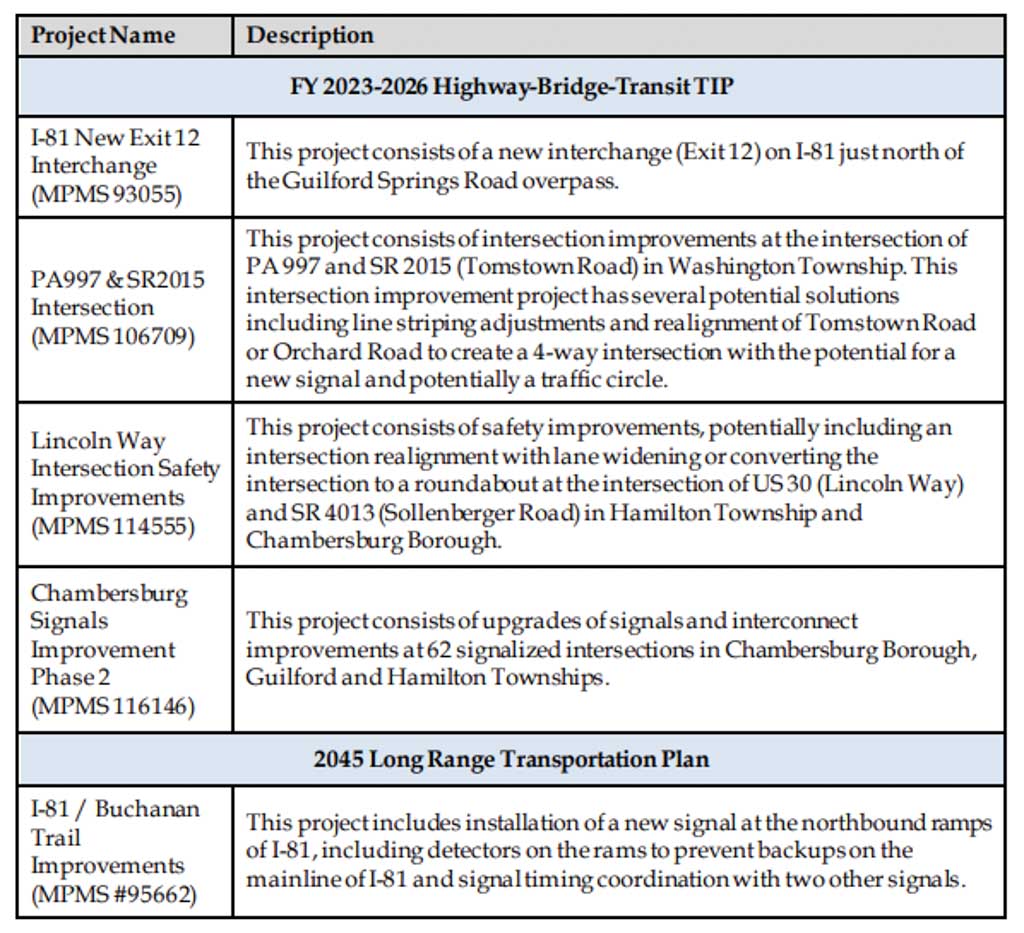
Appendix D: Environmental Justice Assessment
Introduction
The public involvement efforts for MPO/RPOs are guided by several federal mandates to ensure nondiscrimination in federally funded activities. These mandates are designed so that planning and public involvement activities are conducted equitably and in consideration of all citizens, regardless of race, nationality, sex, age, ability, language spoken, or economic status. These mandates include:
- Title VI of the Civil Rights Act of 1964 – Title VI of the Civil Rights Act states that “No person in the United States shall, on the grounds of race, color, or national origin, be excluded from participation in, be denied the benefit of, or be subjected to discrimination under any program or activity receiving federal financial assistance.” MPOs are committed to providing open and inclusive access to the transportation decision-making process for all persons, regardless of race, color, or national origin.
- Executive Order on Environmental Justice (Executive Order 12898 February 11, 1994) – Environmental Justice is the fair treatment and meaningful involvement of all people regardless of race, color, national origin, or income with respect to the development, implementation, and enforcement of environmental laws, regulations, and policies. MPOs/RPOs are committed to providing opportunities for full and fair participation by minority and low income communities in the transportation decisionmaking process.
- Americans with Disabilities Act (ADA) – The Americans with Disabilities Act of 1990 stipulates involving persons with disabilities in the development and improvement of services. Sites of public involvement activities as well as the information presented must be accessible to persons with disabilities. MPOs/RPOs are committed to providing full access to public involvement programs and information for persons with disabilities. All public meetings are held in ADA-accessible locations. With advance notice, special provisions can be made for hearing-impaired or visually impaired participants.
- Executive Order on Limited English Proficiency – Executive Order 13166, “Improving Access to Services for Persons with Limited English Proficiency,” was signed on August 11, 2000. Recipients of federal funding “are required to take reasonable steps to ensure meaningful access to programs and activities by LEP person.” MPOs/RPOs will make special arrangements for the provision of interpretative services upon request.
FHWA recently introduced the Environmental Justice Core Elements Methodology to ensure an MPO/RPO can meaningfully assess the benefits and burdens of plans and programs. Franklin County is committed to following the Core Elements approach, which includes efforts to:
- Avoid, minimize, or mitigate disproportionately high and adverse human health or environmental effects, including social and economic effects, on minority populations and low-income populations.
- Ensure the full and fair participation by all potentially affected communities in the transportation decision-making process.
- Prevent the denial of, reduction in, or significant delay in the receipt of benefits by minority populations and low-income populations.
By integrating the Core Elements into the planning process, state and local agencies are better equipped to carry out the investment strategy and project selection. The EJ process should be comprehensive and continuous with each task informing and cycling back to influence the next step.
Identifying Minority and Low-Income Populations
In developing its 2045 Long Range Transportation Plan (LRTP), Franklin County conducted an Environmental Justice Benefits and Burdens analysis. A distributive geographic analysis was conducted to identify the locations and concentrations of minority, low-income and other Traditionally Underserved Populations (TUP). The identification of these populations is essential to establishing effective strategies for engaging them in the transportation planning process. When meaningful opportunities for interaction are established, the transportation planning process can effectively draw upon the perspectives of communities to identify existing transportation needs, localized deficiencies, and the demand for transportation services. Mapping of these populations not only provides a baseline for assessing impacts of the transportation investment program, but also aids in the development of an effective public involvement program. Minority population is defined as any readily identifiable group of Black, Hispanic, Asian American, American Indian, and Alaskan Native who live in geographic proximity and who would be similarly affected by a proposed FHWA program, policy, or activity.
Low-income population is defined as any readily identifiable group of persons at or below the Department of Health and Human Services poverty guidelines who live in a geographic proximity who would be similarly affected by a proposed FHWA program, policy, or activity. As shown in Table EJ-1, based on the 2015-2019 American Community Survey (ACS) data, minority persons in Franklin County make up nearly 14 percent of the total population. The number of persons in poverty is just above 9 percent of the total regional population. Table EJ-2 identifies the total population by race and low-Income category. The White, Non-Hispanic category has the highest population in the county and most individuals that are low-Income, however, the category’s overall low-income percentage is about 9 percent, which is about the same as the county average of 9.25 percent. In contrast, nearly 25 percent of the Hispanic population and nearly 72 percent of the Native Hawaiian category is considered low income.
Condition Assessment
In order to meaningfully analyze benefits and adverse effects of the transportation program, Franklin County has examined the existing conditions of transportation assets throughout the county and safety performance measures among the minority and low-income populations. These data assessments allow the county to track changes in crashes, poor condition bridges, and poor pavement mileage in the region and identify safety gaps and distribution disparities between minority and low-income populations.
Bridges
Tables EJ-3 and EJ-4 provide the number and percentage of bridges by condition and by the concentration of minority and low-income population. Comparing the distribution of total bridges and poor condition bridges between low and high minority and low-income areas helps provide insights on potential equity issues. For areas with higher minority population shares, the percentage of total bridges and poor bridges is 27.2% and 28.5%, respectively. For areas with higher shares of low-income population, the percentage of total bridges and poor bridges is 26.2% and 34.4%, respectively. In both cases the share of poor condition bridges is near the percentage of total bridges in minority and low-income areas. The data does not indicate any disproportionate impacts to those communities related to bridge asset conditions.
All Reported Crashes
Tables EJ-5 through EJ-8 show the number and percentage of crashes in Franklin County from 2015-2019 in areas of varying minority and low-income shares. This data is reviewed to identify if any disproportionate numbers of crashes occur in areas with high shares of minority or low-income population. As shown in Table EJ-5, about 42 percent of the total crashes occur within block groups that have higher shares of minority population, while nearly 58 percent of crashes occur
in block groups with lower shares of minority population. Similarly, nearly 36 percent of crashes occur within block groups that have higher shares of low-income populations, while 64 percent of crashes occur in block groups with lower shares, as shown in Table EJ-6. This data does not indicate disproportionate impacts for minority or low-income populations related to total crashes, fatalities or serious injuries.
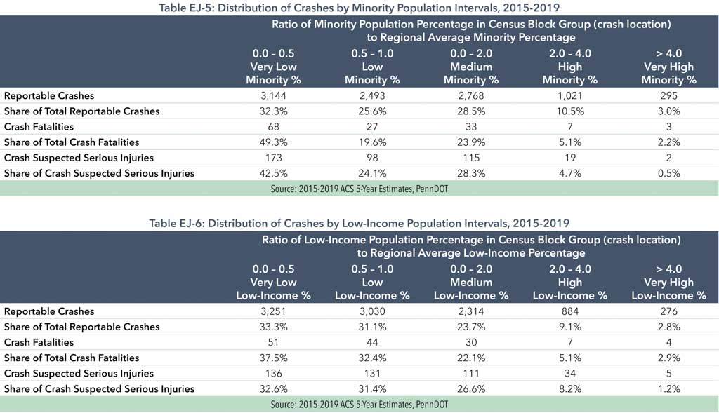
However, the bicycle and pedestrian crashes shown in Tables EJ-7 and EJ-8 show much higher numbers and percentages in areas with a higher share of minority populations. This may be a result of higher
levels of pedestrian and bicycle activity and usage in those areas. Franklin County will continue to review and evaluate safety needs for these populations in its planning process.
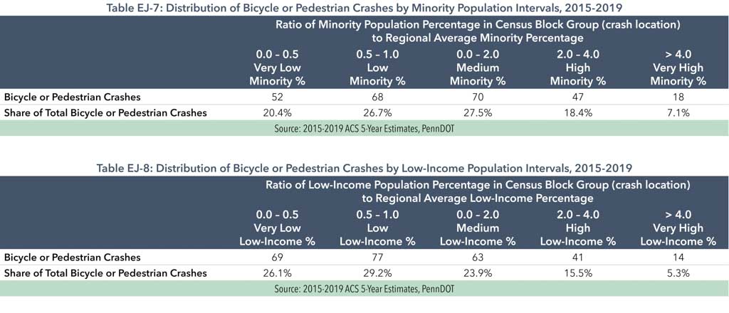
Pavement Condition
Tables EJ-9 and EJ-10 identify the number and percentage of roadways with poor International Roughness Index (IRI) and with poor Overall Pavement Index (OPI) within minority and low-income population block group intervals. Poor pavement condition data in Franklin County may indicate a need for increased roadway resurfacing
and reconstruction. The data indicates that poor rated IRI and OPI pavement occurs at nearly equal amounts between areas with and without high shares of low-income and minority populations. The data does not indicate any disproportionate impacts to those communities related to pavement conditions.
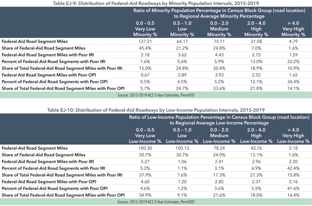
Benefits & Burdens of the 2045 Long-Range Transportation Plan
Franklin County reviewed transportation projects located in areas that were determined to have higher than average minority and lowincome levels. When evaluating the potential benefit or burden of a project, it should be noted that each type of project has a unique set of impacts and will affect individual populations differently. For example, maintenance projects tend to cause the least amount of impact on the population since they typically involve highway resurfacing or repaving work on existing roadways. Although these projects can cause delayed travel time and transit service, traffic detours, and work zone noise and debris, the projects are typically shorter in duration and result in improvements to the functionality of the roadway network by providing smoother driving surfaces and new roadway markings. While most bridge projects are identified as either a rehabilitation or replacement, both types of projects can lend itself to significant traffic detours, traffic delay, and noise. However, the benefits of these types of improvements result in safer bridge structures, improved roadway conditions and updated signage.
Capacity projects, which can involve the addition of new lanes to existing roadways, new roadways to the existing network, or at times the realignment of intersections or interchanges, in an effort to provide for more traffic mobility. Special attention needs to be made when planning capacity projects, especially to low-income
and minority populations. Not only can these projects result in right-of-way acquisitions to account for the additional capacity, but also construction impacts are normally more severe due to longer construction periods, travel pattern shifts, and delayed travel times among others. The consequences of the completion of capacity projects can involve the loss of property, increased traffic volumes, and decreased air quality, while other benefits can include improved transit service time, decreased travel delay, and safer roadway conditions which will result in improved quality of life for all residents and users of the roadway system.
Of all locatable projects on Franklin County’s 2045 LRTP, the number of projects in minority or low-income areas is lower than the number of projects located in non-minority and non-low-income areas. Tables EJ-11 and EJ-12 depict the types of projects and funding investments in each minority/income interval. Figures EJ-1 and EJ-2 illustrate the geographic proximity between different LRTP projects and the concentrations of minority and low-income populations by Census block groups based on 2015-2019 ACS data. Franklin County will continue to evaluate needs and investment opportunities in these areas to ensure all communities share in transportation investment benefits.
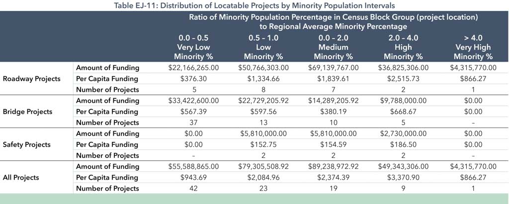
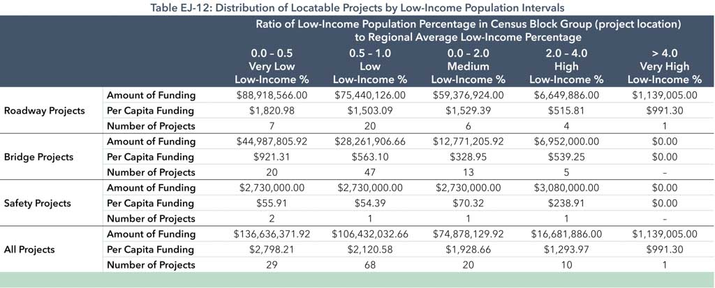
Figure EJ-1: Concentrations of Minority Populations by Census Block Groups & LRTP Project Locations
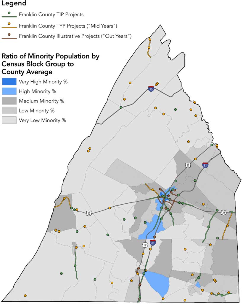
Figure EJ-2: Concentrations of Low-Income Populations by Census Block Groups & LRTP Project Locations